
[WpProQuiz 30]

[WpProQuiz 30]
6/6
5 of 6 questions answered correctly
Your time: 00:01:27
You have reached 5 of 6 scores, (83.33%)
first
6 of 6 questions answered correctly
Your time: 00:02:26
You have reached 6 of 6 scores, (100%)
Average score 51.97%
Your score 100%
Ain’t western coast an emergent coast?
5 of 6 questions answered correctly
Your time: 00:04:48
You have reached 5 of 6 scores, (83.33%)
I think its wrong. Bhabar is not an agricultural belt, nor can it be considered plainland topography. Dooars, on the other hand, despite considerable altitude, has been under plainland cultivation sphere and considered a part of the Gangetic plains since antiquity. However, most of Bhabar region remains forested, out of cultivation sphere and mostly unsuitable for plainland agriculture.
Besides, the Bhabar in India lies in Punjab/Himachal region that is considered north of the Gangetic plains. Only the Bhabar in Nepal is contiguous with Gangetic plains. Another point where Bhabar shouldnt be considered a part of India’s northern plains.
Results
6 of 6 questions answered correctly
Your time: 00:01:16
You have reached 6 of 6 scores, (100%)
Average score 51.73%
Your score 100%
Categories
Geography100%
Thanks for attempting the Quiz
Just a suggestion…. Please do not take it otherwise…
Just do not over-think in UPSC questions… One has to see the context by looking at the other options as well… As other mentioned water bodies and hence the most suited one had to be choosen.
This is why practicing questions in mock becomes important.
6/6.. But ephemeral river wala totally tukka tha..
6 out of 6 correct…. feeling good.. 🙂
5/6.
Luni is also an endorheic river, a term for rivers/water bodies that retain water and allows no outflow to other external bodies of water.
I have one serious doubt related to Minocoy Island question: Minicoy is in Lakshadweep so basically if someone looks at the proximity answer should be D i.e. None of the above. However, answer ‘Arabian Sea’ is also correct but correct answer can be ‘None of the above’!! Please clear this if someone has more clarity. Suppose I ask, Delhi is part of a. Northern Hemisphere b. Asia c. Europe d. None of the above. Here answer can be B or D!!
Thanks ForumIAS
4/6 today feel bad
Your time: 00:03:39
You have reached 4 of 6 scores, (66.67%)
Average score 52.1%
Your score 66.67%
Is upsc really going to ask this type of questions? Don’t make quizzes just for the sake of making them.
4 of 6
00:03:12
yes bro… Bhabar is north of terai region….
Consider not in the questn
I think the same one should be the answer
But, NCERT mentions it under the northern plains.
3/6
Ohkk, thanks
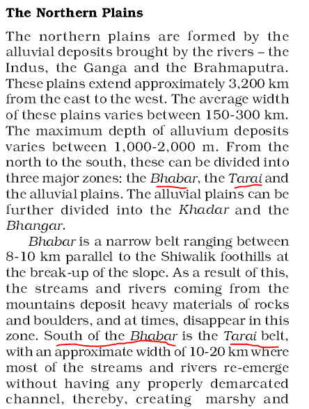
The Terai ( Nepali: तराई Hindi: तराइ ) is a plain region of Nepal and the plain land region in Bangladesh, Bhutan and India that lies in south of the outer foothills of the Himalaya, the Siwalik Hills, and north of the Indo-Gangetic Plain of the Ganges, Brahmaputra and their tributaries. This lowland belt is characterised by tall grasslands, scrub savannah, sal forests and clay rich swamps. In northern India, the Terai spreads eastward from the Yamuna River across Himachal Pradesh, Haryana, Uttarakhand, Uttar Pradesh and Bihar. The Terai is part the Terai-Duar savanna and grasslands ecoregion. Corresponding parts in West Bengal, Bangladesh, Bhutan and Assam east to the Brahmaputra River are called ‘Dooars’.[1] In Nepal, the Terai lies at an altitude of between 67 and 300 m (220 and 984 ft) and comprises more than 50 wetlands. North of the Terai rises the Bhabhar, a narrow but continuous belt of forest about 8–12 km (5.0–7.5 mi) wide.[2]
Source: wikipedia
I think answer is okay. Bhabar is north of Northern plains, but Duars are found all across Terai region of Northern Plains.
I think question is okay. Bhabar is found North of Terai, and Duars is a Terai based ecoregion. Also Terai-Duar plains exist all along the Northern Plains on the Nepalese foothills. Therefore, Duars is a part of Northern Plains but Bhabar is not,
True
5/6
?
@ForumIAS — Thank you so much Sir/Ma’am. 🙂
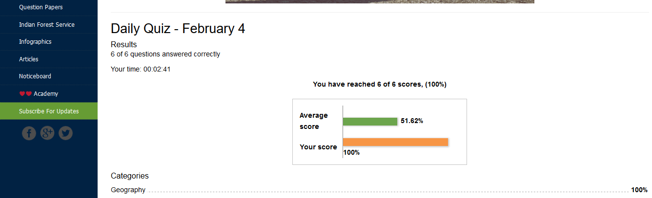
Daily Quiz – February 4
Results
5 of 6 questions answered correctly
Your time: 00:02:59
You have reached 5 of 6 scores, (83.33%)
Average score 52.55%
Your score 83.33%
Categories
Geography83.33%
Thanks for attempting the Quiz.
5 ki khushi nahi 1 ka dukh ho raha he aaj.
Forum IAS if time permits plzzzx solve doubt related to question 1.
ho jaaega, very soon
Same question also hitting in my mind..
Yes.
no anirudh bhai , what i want to say is soils are distributed there.
hilly soil and alluvial flood plain , both are different . hilly soil used or tea plantation and alluvial used for rice and jute.
right…..
“assam plain is used for rice and jute cultivation”
You mean tea is not grown in Assam?
and “not used in tea garden”
You mean Tea is not grown in Dooars?
ans should be 1 only….
i guess – Q-1 is the only wrong one.
bhai ncert se but tumko galat kya lag rha hai
Northern plain rom north to south
1st- bhabar contain boulder and clay-water dissappear.
2nd terai- muddy – good gor cultivation.
3rd-Alluvial plain-3(a) bhangar -old alluviam
2(b) khaddar new alluviam
waah…..hamara to ab tak nahi hua
aisa kahan padh liya dada tumne?
bhai – aaj kamaal kar diye tab, If D happens to be the right answer, for the first time in history, I will score a SIXER 🙂
yah but not used in tea garden
the catch is tea plantation takes place on hilly slope and assam plain is used for rice and jute cultivation ,
4/6
5 of 6 questions answered correctly
Your time: 00:02:36
You have reached 5 of 6 scores, (83.33%)
But if you see 11th class NCERT , Duars are given under Darjeeling and Sikkim Himalayas …..
hmmm…. D hi hona chahiye
Daily Quiz – February 4
Results
5 of 6 questions answered correctly
Your time: 00:01:59
You have reached 5 of 6 scores, (83.33%)
Average score 53.41%
Your score 83.33%
Categories
Geography83.33%
Thanks for attempting the Quiz.
yeah
5 of 6 questions answered correctly
Your time: 00:01:49
You have reached 5 of 6 scores, (83.33%)
Something wrong with question 1?
hi
its punjab plain, ganga plain, bengal delta and assam plain are the part of northern plains.
So answer should be D. I marked D, but it is showing B.
Bhabhar is found north of Terai…..where rivers disappear…..but ques is asking whch is “Not” associated with northern plain
Duars are terai floodplains. They are made up of lose sediments brought down by Himalayan rivers and deposited each season. Since they are fine sediments the streams more often than not shift course and spread the load over broad tracts. Some streams disappear underground and reemerge only later. This makes duars very damp regions. Duars are not the peneplains though. They may have considerable height and are great for growing crops like tea and coffee. Where a river cuts through the mountain, flood plains valleys are formed. These serve as excellent low passes.
Source : Quora
Duars are floodplains and foothills of Himalayas in North-Eastern state Assam and northern part of West Bengal
And hence, they are part of Northern Plains according to me.
But, isn’t Bhabhar found north of Terai plains ?
Q1 is saying “which of the following is not a feature associated with Northern plains ” ….. so answer should be 1 as Duar formations exist in Himalayas (Darjeeling )
2/6
Daily Quiz – February 4
Results
5 of 6 questions answered correctly
Your time: 00:03:32
5/6
and i have a doubt in question 1 (a)
2/6
Leave a Reply