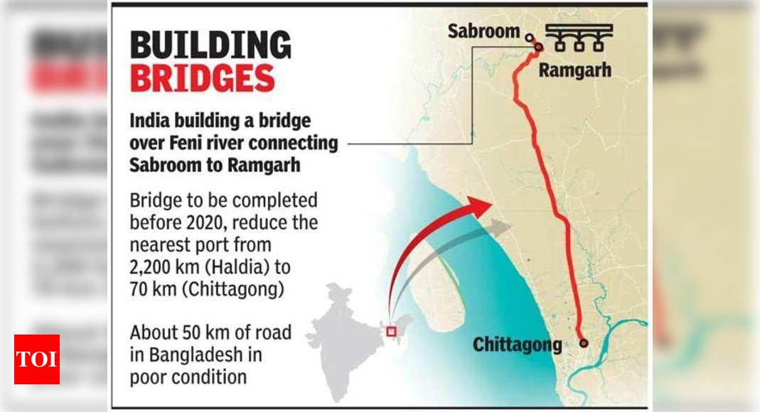
Subscribe to ForumIAS

Places in news for CSE Prelims 2021

1. Duqm Port, Oman

India secured access to Duqm port on Oman’s south-eastern seaboard that is ideally situated between two other Chinese strategic jewels: Gwadar port on Pakistan’s Makran coast and Djibouti on the Horn of Africa.

Oman Duqm port: Access to Omani port to help India check China at Gwadar |  India News - Times of India

43.4k views

2. Bougainville Island

- largest island of the Solomon Islands Archipelago.

- island has the world’s largest copper deposits.

- south Pacific Archipelago of Bougainville voted to become independent of Papua New Guinea.

Map of Papua New Guinea - Papua New Guinea Map, Geography of Papua New  Guinea Map Information - World Atlas

43.4k views

4.Puerto Williamsin Chile has become world’s southernmost city after its status upgraded from hamlet to city. It took over the title from Ushuaia in Argentina which was world’s southernmost city till recently.

Puerto Williams: World's Southernmost City - Current Affairs Today

39.4k views
5. India is developing its maiden deep-sea port in Indonesia'sSabangclose to Andaman and Nicobar Islands making its maiden foray in the southeast Asian amid China’s slew of connectivity plans for ASEAN under BRI.

India's coastline now 'extends' from Seychelles to Indonesia | India News -  Times of IndiaIndia's Tsunami Relief For Indonesia Supplements A Strategic Pacific Twist  - Strategic News International
43.4k views

6. Feni River

The Feni river, which forms part of the India-Bangladesh border, originates in the South Tripura district, passes through Sabroom town on the Indian side, and meets the Bay of Bengal after it flows into Bangladesh.The dispute over the sharing of the river water has been long-standing.Joint Rivers Commission (JRC) in Dhaka, agreed to collect data and prepare water-sharing agreements for seven rivers — Manu, Muhuri, Khowai, Gumti, Dharla, Dudhkumar, and Feni.
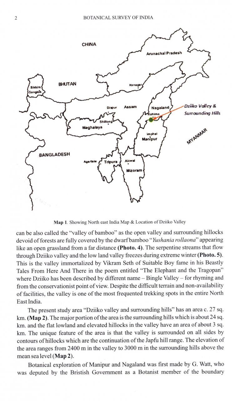
For better link, India seeks to widen 35km of Bangladesh road | India News  - Times of India

39.3k views

7.Etalin Hydropower Project Arunachal Pradesh- construction of two dams over the tributaries of Dibang: Dir and Tangon. JV with Jindal Power.

Etalin Hydel Plant's Future Now Hangs on Its Economic Viability - The Wire  Science 

39.1k views

8.YettinaholeRiver Diversion project aims to divert water from four perennial streams of River Nethravati in the Western Ghats of Karnataka towards drought-hit districts in Karnataka.

Yettinahole project - INSIGHTSIAS

39.3k views
9. Dardanelles Strait is a narrow, natural strait and internationally significant waterway in northwestern Turkey that forms part of the continental boundary between Europe and Asia, and separates Asian Turkey from European Turkey.The Dardanelles connects the Sea of Marmara with the Aegean and Mediterranean Seas, while also allowing passage to the Black Sea by extension via the Bosphorous. 
STRAITS NAVIGATION - Arkas Holding S.A.Dardanelles | Strait, Map, History, & Meaning | Britannica
38.8k views

10.Gulf of Alexandretta,also known as the Gulf of Issus or Gulf of İskenderun, forms the eastern most boundary of the Mediterranean Sea at the southern coast of Turkey near its border with Syria. It is a gulf or inlet of the Levantine Sea, the eastern part of the Mediterranean basin.


Mediterranean Navy Ports

38.8k views

11. Thitu Island:known as Pag-asa (“Hope Island”) in the Tagalog language of the Filipinos who inhabit it – has become  increasingly contentious geopolitical dispute involving the Philippines, China and four of their Pacific Rim neighbors: Brunei, Malaysia, Taiwan and Vietnam.

Manila wants South China Sea outpost to be tourism draw, SE Asia News & Top  Stories - The Straits Times

38.8k views

12.Masirah Islands- Oman - one of the largest nesting grounds of Loggerhead Turtles in the world - population trend of Loggerhead Turtles shows that there has been a 79 per cent decline in the nesting population on the Masirah island.

Oman - Masirah Island - Hitchhiking - Mentawai

13.9k views
13. Odisha’s largest freshwater lake,Ansupa Lake, which silted up following drastic reduction of water inflow from the Mahanadi, is being redeveloped by intervention initiated by the State government. 
Chilika Development Authority, the nodal agency, has taken up restoration measures under funding from National Plan for Conservation of Aquatic Ecosystems.
10.9k views

Five Sites are:

  1. Rakhigari (Haryana)
  2. Hastinapur (Uttar Pradesh)
  3. Sivasagar (Assam)
  4. Dholavira (Gujarat)
  5. Adichanallur (Tamil Nadu) 
14k views
14. Chite Luiis a river that runs through Aizawl in Mizoram and has high sentimental value attached to it. However, rampant urbansation has left the river dying. River originates from Bawngkawn range in north Aizawl and flows through a distance of around 20 kilometres in eastern Aizawl before joining the Tuirial river at the southern end of the city.
10.1k views
15. Absence of secondary algae in the reef areas ofShingle Island (Gulf of Mannar) confirmed the recent death of coral colonies due to the smothering effect of the microalgae .
10k views

16.Sakteng Wildlife Sanctuary - Bhutan


10k views

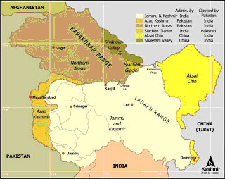
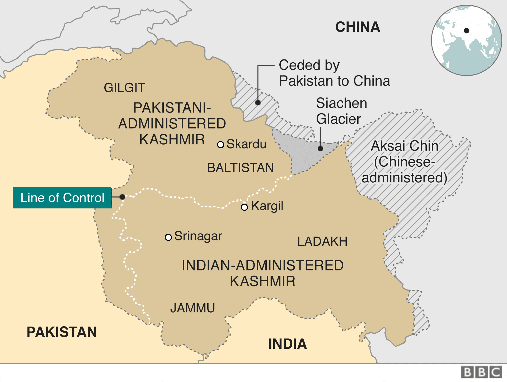
18. Shaksgam Valley: Shaksgam Valley or the Trans Karakoram Tract is part of Hunza-Gilgit region of Pakistan Occupied Kashmir (POK), and is a disputed territory claimed by India but controlled by Pakistan. It borders Xinjiang Province of the People’s Republic of China (PRC) to the north, the Northern Areas of POK to the south and west, and the Siachen Glacier region to the east. Shaksgam Valley was ceded to China by Pakistan in 1963 when both countries signed a boundary agreement to settle their border differences. 

Brijesh P asked: Why did Pakistan and under what terms and conditions cede  the Shaksgam Valley to China? What is the geo-strategic significance of the  Valley? | Manohar Parrikar Institute for Defence

12.9k views

Nord Stream 2is a new export gas pipeline running from Russia to Europe across the Baltic Sea.


8.5k views

Port Antsiranana in Madagascar:INS Kesari gave COVID-19-related medical supplies. This is part of Mission Sagar under which the Indian government is providing assistance to friendly foreign countries in dealing with the COVID-19 pandemic.

Where is Antsiranana Located? What Country is Antsiranana in? Antsiranana  Map | Where is Map

8.8k views

Port Moroni, Comoros

Western Indian Ocean is emerging as key strategic partner in the region and Comoros backs India at various fora including OIC. The Covid pandemic brought two countries closer. A consignment of COVID-19 related essential medicine supplies from India arrived at the port of Moroni, Comoros in Western Indian Ocean onboard INS Kesari.


Political Map Of Comoros With Capital Moroni, Important Cities.. Royalty  Free Cliparts, Vectors, And Stock Illustration. Image 34188488.

8.8k views

Amery Ice Shelf, Antarctica

Amery Ice Shelf is one of the largest glacier drainage basins in the world, located on the east coast of Antarctica. Iceberg broke off and large ice chunks can pose a danger to ships that navigate through Antarctic waters.


SOTC: Ice Shelves | National Snow and Ice Data Center

8.7k views

Ambarnaya River & Lake Pyasino , Russia

Diesel fuel from a 21,000-ton oil spill in the Russian Arctic has reached a freshwater lake that serves as a gateway into the Arctic Ocean. Oil leaked into the Ambarnaya river that flows into the environmentally sensitive Arctic Ocean. This oil spill is believed to be the second largest in modern Russian history in terms of volume.

Arctic Oil Spill in Norilsk, Russia | EJAtlas

8.6k views

Myanmar Economic Corridors.

Myanmar’s Economic Corridors

8.6k views
Zealandiais a long, narrow micro-continent that is mostly submerged in the South Pacific Ocean.
A micro-continent is a landmass that has broken off from a main continent. Zealandia broke off from Antarctica about 100 million years ago, and then from Australia about 80 million years ago.

What is Zealandia? Landmass under New Zealand that could become earth's  eighth continent
8.6k views

Skardu Airbase, PoK: Amid Sino-India border along the Line of Actual Control in Ladakh, Indian intelligence agencies have recently noticed activities of the Chinese Air Force at Skardu Airbase in Pakistan occupied Kashmir (PoK). For the Chinese Air Force, it will be easier to attack Indian bases, both Ladakh and Kashmir, from Skardu, which is around 100 km away from Leh, while Kargil is around 75 km. 

Kargil: The forgotten victims of the world's highest war - BBC News

8.6k views

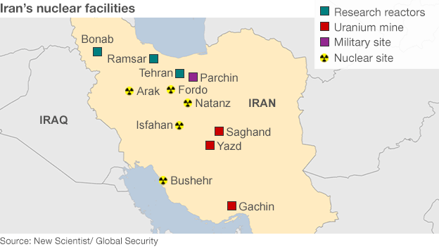
Natanz Fuel Enrichment Plant (FEP), in Ishfan, Central Iran,is the country’s main uranium enrichment site. The Natanz facility is mostly underground and one of several Iranian facilities monitored by inspectors of the International Atomic Energy Agency (IAEA), the U.N. nuclear watchdog. On July 2, 2020, fire broke out at the Natanz nuclear facility causing explosions that damaged a building that housed centrifuge machines.

Iran's key nuclear sites - BBC News

8.2k views
Viking Link: world’s longest subsea power cable, which will run between Britain and Denmark to share renewable energy between the two countries.
The 475-mile (765km) cable is a joint-venture between National Grid in the UK and Denmark’s Energinet. By 2023, the high-voltage, direct-current link will transmit the equivalent of enough electricity to power 1.5m British homes between Bicker Fen in Lincolnshire and the South Jutland region in Denmark.

Work begins in Lincolnshire on world's longest subsea power cable. |  e-mc2.gr
8.2k views

The landlocked mountainous region ofNagorno-Karabakhis the subject of an unresolved dispute between Azerbaijan, in which it lies, and its ethnic Armenian majority, backed by neighbouring Armenia.


8.2k views
Can anybody share map of the actual places of confrontation b/n india n china

Hope this helps. 

India China border dispute: US slams China's 'disturbing behaviour' at  India border | India News - Times of IndiaIndia, China Border Dispute In Ladakh As Dangerous As 1999 Kargil  Incursions - Experts

8.2k views
Mousuni Island in West Bengal’s Sundarbans region was severely impacted August 20-21, 2020 by extreme weather and other cyclones. 
9.5k views
VP Visit: threeBaltic countries of Lithuania, Latvia and Estonia in the first such high-level trip from India. The visit aims to advance India's outreach to the important countries that border the Baltic Sea.
It is also expected to give a fillip to India's keenness to push the International North-South Transport Corridor project that aims to link the Indian Ocean with the Baltic Sea and provide seamless connectivity.

Fading Russian Influence in the Baltic States - ScienceDirect

10.4k views

Hindu Kush Himalayas, a region called “theThird Pole” because its glaciers and permafrost contain the largest freshwater resources outside Antarctica and the Arctic.

The geographical location of the Third Pole. The Third Pole stretches... |  Download Scientific Diagram

9.5k views

In the middle of the Sea of Japan, almost equidistant between Japan and Korea -Dokdo Islands or TakeshimaIslands depending on who is asking—are at the center of a diplomatic dispute between the two countries that goes back more than 300 years.

Inter-Korean summit chairs to feature disputed islands

9.4k views

Agogsaid

@upsc2020 These hav been missed on big room map chart by producers!!


what, didn't understand?

9.4k views
Island of Crete: Crete is the largest and most populous of the Greek islands. Was in news wrt purchase of Rafale. 
8k views
Iran has offered interests to China in theBandar-e-Jask port350km away from Chabahar, as well as in the Chabahar duty free zone.
7.4k views
Paparva Islandis located between Kandla port and Navlakha port, in the Gulf of Kutch (Gujarat). The island is uninhabited but local fishermen go there to dry their fish.
7.4k views
Vanilla Islandsis a grouping of six island nations in south-west Indian Ocean who joined hands in 2010 to integrate their efforts to boost tourism.Mayotte, Comoros, Mauritius, Seychelles, Reunion and Madagascarare its members.

The term ‘Vanilla’ is used because these countries are known for their export of the flavouring substance Vanilla.
7.4k views
Mekedatu Project:

  • Proposed to be constructed on Kaveri and Arkavathi
  • Proposed reservoir site is Ontigondlu, Karnataka
  • Threatens to submerge more than 60% of Kaveri Wildlife Sanctuary
10.5k views
Lingdum monasteryin RankaSikkim- famous for Singhi and Mask dances.

President visited.
10.1k views

@Haryana This thread can be utilised

9.2k views
@upsc2020 need to reinvent this thread for csp21.
You appearing cse21?


Yes. 

8.9k views
The isolated UK Overseas Territory of Tristan da Cunha declared the largest fully protected marine reserves in the Atlantic Ocean at 687,000 square kilometres. 

It is a remote group of volcanic islands in the south Atlantic Ocean. This archipelago is off the coast of Cape Town in South Africa.
9.1k views
Tatar Strait (Strait of Tartary)
 
-  Joins : Japan Sea & Okhotsk Sea
 - Location: Russia (East Russia-Sakhalin Islands)


8.5k views
Human Damis an earthfill and gravity dam on the Human river near Chandrapur in the state of Maharashtra in India. Proposed on the river Human at Tadoba Andhari Tiger Reserve in Chandrapur district threatens to submerge more than 90 per cent of a 7-km forest area.
7.1k views
Tristan da Cunhais inhabited by less than 300 humans. 
● It is a small chain of islands over 6,000 miles from London in the South Atlantic and the water around the islands are considered to be the richest in the world.
● It is an UK Overseas Territory. It was recently declared the largest fully protected marine reserves in the Atlantic Ocean at 687,000 square kilometres.

Tristan da Cunha | island group, Atlantic Ocean | Britannica
7k views

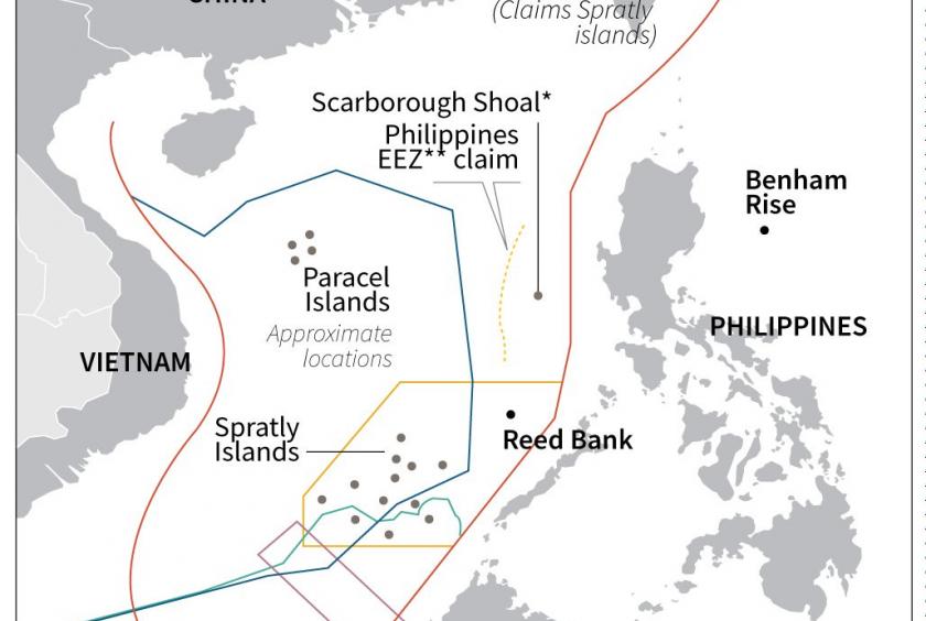
Philippine president has approved the lifting of a ban on oil and gas exploration in or near disputed areas of the South China Sea that was imposed six years ago because of escalating territorial tensions with China. 

Companies awarded contracts to explore for oil and gas in three sprawling areas off the western Philippines have been asked to resume their search operations, including in a potentially oil- and gas-rich region calledReed Bank.


China could seize gas in Reed Bank if PH can't pay loans – Philippine judge  | #AsiaNewsNetwork | Eleven Media Group Co., Ltd

Taiwan-occupied Itu Aba (or Taiping Island) in the South China Sea is now  officially a

7k views

Pakistan Rattled As India And Afghanistan Signed MOU To Build Shahtoot Dam  In Kabul -

India to buildShatoot Dam in Afghanistan on Kabul River. 

700-km-long Kabul River originates in the Hindu Kush Mountains in central Afghanistan. It flows eastward past the Afghan cities of Kabul, Surobhi, and Jalalabad. East of Jalalabad, it is joined by its main tributary, the Kunar River, which originates in Pakistan, where it is known as the River Chitral. Afghanistan and Pakistan are thus upstream and downstream basin states with regard to the Kabul River.

After crossing into Pakistan’s Khyber Pakhtunkhwa province, the Kabul River runs past Peshawar and Nowshera and joins the mighty Indus River near Attock, northwest of Islamabad.

The Kabul River Basin extends over nine Afghan provinces and two Pakistani provinces.

7k views
Long forest fire inDzukou valleyon Nagaland-Manipur border. The 90-sq km green valley has been prone to forest fires for decades.

Situated at an altitude of 2,438 metres behind the Japfu mountain range, it is one of the most popular trekking spots in the North East. Dzukou valley and Japfu peak are located adjacent to the Pulie Badze Wildlife Sanctuary (Nagaland).
There are no human habitations within the forests, but they are home to rare and ‘vulnerable’ (as per the IUCN Red List) birds - Blyth’s Tragopan (Nagaland’s state bird), the Rufous-necked Hornbill and the Dark-rumped Swift, among many others. Also found in the forests are endangered Western Hoolock Gibbons.
It is covered with bamboo and other grass species. The valley harbours many species of flowering plants including the endemic Dzukou Lily- Lilium chitrangada.
The valley is a source of conflict for ownership between local tribes and the state governments of Manipur/Nagaland. It is home to the Angami people.

Flora of Dziiko/Dzukou valley | NHBS Academic & Professional Books
7k views


6.6k views
Bhasan Char, the site where Bangladesh is sending Rohingya refugees from the overcrowded camps at Cox’s Bazar, is an island formed by sedimentation (char is Bengali for sediment) close to the coast. Bhasan Char is less an island and more mud flat, and is vulnerable to going under water from tides and flooding. Much of it is submerged during the monsoon. Located near the mouth of the river Meghna where it flows into the Bay of Bengal, Bhasan Char surfaced only in 2006 from the sediment deposited by the river.

It is estimated that more than 8 lakh Rohingya, who fled an army crackdown in Myanmar’s Rakhine Province in 2016 , live in the camps at Cox’s Bazar in unhygienic conditions. Bangladesh’s plan is to move some 1 lakh refugees to Bhasan Char, 39 km from Naokhali on the mainland.

Bhashan Char: Superior to Cox's Bazar but Rohingyas, UN not yet convinced |  Dhaka Tribune
6.3k views
Northernmost town in the world is also the fastest-warming place on the planet.Longyearbyen, the capital of the Svalbard archipelago located between Norway and the North Pole.

Temperatures in the town have risen by 4 degrees Celsius since 1971. That is five times faster than the global average. During winters, the temperature has gone up by 7°C. 

12.1k views
Pearl River estuaryincludes Hong Kong, Macau as well as the mainland Chinese cities of Shenzhen, Guangzhou and Dongguan.
Chinese pink dolphins are making a comeback in the Pearl river estuary, one of the most heavily industrialised areas on Earth.
Spatial-temporal variations and trends predication of trace metals in  oysters from the Pearl River Estuary of China during 2011–2018 -  ScienceDirect
8.9k views


Lakshadweep 

8.2k views


Andaman & Nicobar Islands

8.1k views


7.6k views
Dima Hasao -- earlier called North Cachar Hills district is an administrative district in the state of Assam in north-eastern India. "Dima Hasao" means "Dimasa Hills" in the Dimasa language. As of 2011, it is the least populous district of Assam. 
7.2k views
Write your comment…