Study Approach
Start with the Big Picture
Begin by understanding Asia as a complete geographical system rather than studying individual topics separately. Follow the chapter in a logical sequence:
Physiography → Climate → Drainage → Vegetation → Resources → Agriculture → Transport & Trade → Geopolitical Importance
This sequence helps you understand how physical features influence climate, how climate affects rivers and vegetation, and how all these factors shape human activities, economic development, and strategic importance.
Major Study Blocks
- Physiography of Asia
This is the foundation of the entire chapter.
Focus on:
- Mountains, plateaus, plains, deserts, and island arcs.
- Relationship between the Indian Plate–Eurasian Plate collision and present landforms.
- Location-based understanding rather than rote learning.
Memorize:
- Major mountain ranges.
- Important peaks.
- Major plateaus and deserts.
Understand Conceptually:
- Why Tibet is called the “Roof of the World.”
- Why the Himalayas influence climate and rivers.
- Drainage System and Lakes
Study rivers through a source-based approach.
Create classifications:
- Rivers originating from the Tibetan Plateau.
- Rivers flowing into different oceans.
Memorize:
- Major rivers and their origins.
- Caspian Sea, Lake Baikal, and Dead Sea.
Understand:
- Importance of glaciers and snowmelt.
- Why Tibet is called the “Water Tower of Asia.”
- Climate and Monsoon
This is the most important conceptual block.
Focus on:
- Factors influencing climate.
- Summer and winter monsoon mechanisms.
- Role of Himalayas and Tibetan Plateau.
For Mains:
Link climate with agriculture, water resources, disasters, and economy.
Practice repeatedly:
- Monsoon flow diagrams.
- Orographic rainfall diagrams.
- Natural Vegetation and Wildlife
Study vegetation as a climate outcome.
Memorize:
- Tundra, Taiga, Steppe, Monsoon Forests, Rainforests.
- Important species and their habitats.
- Resources, Agriculture and Fisheries
Focus on resource distribution patterns.
Prepare one-page tables:
- Petroleum regions.
- Coal regions.
- Rice and wheat belts.
- Plantation crops.
Prelims Focus:
Major producers and resource locations.
Mains Focus:
Resource-based development and food security.
- Transport, Trade and Strategic Importance
Study maps carefully.
Focus on:
- Major ports.
- Trans-Siberian Railway.
- Strategic chokepoints.
Understand why:
- Strait of Malacca,
- Strait of Hormuz,
- Bab-el-Mandeb,
- South China Sea
are important for global trade and energy security.
How to Read Each Block
Follow a fixed sequence:
Location → Characteristics → Importance → Exam Relevance
Diagram-Based Preparation
Practice these diagrams repeatedly:
- Physical map of Asia.
- Major mountain systems.
- Tibetan Plateau and river origins.
- Asian monsoon circulation.
- Vegetation zones.
- Strategic chokepoints map.
- Resource distribution map.
Map-based practice is essential for both Prelims and Mains.
Important for Prelims
- Peaks and mountain ranges.
- Plateaus and deserts.
- River origins.
- Lakes and their unique features.
- Ocean currents.
- Vegetation types.
- Resource-producing regions.
- Strategic straits and ports.
Important for Mains
- Himalayan significance.
- Tibetan Plateau’s role.
- Asian monsoon mechanism.
- Climate–agriculture relationship.
- Resource distribution and development.
- Trade routes and geopolitical importance.
- Asia’s role in the global economy and energy security.
ASIA
| Table Content |
| Physiographic Structure |
| Drainage System |
| Climate and Monsoon of Asia |
| Agriculture |
| Minerals and Energy |
Asia is the largest and most populous continent, covering about 44.58 million sq. km and accounting for nearly 30% of the world’s land area and 60% of the global population. It is often called the “Continent of Contrasts” because it contains the world’s highest mountains, largest plateau, deepest lake, vast deserts, fertile plains, and ancient civilizations. Asia extends from the Arctic Ocean in the north to the equatorial islands of Southeast Asia in the south and is bounded by the Pacific Ocean in the east and the Indian Ocean in the south.
Physiographic Structure
Asia’s relief is highly diverse and consists of:
- Northern Lowlands
- Central Highlands
- Southern Plateaus
- River Plains
- Island Arcs
The collision of the Indian Plate with the Eurasian Plate played a major role in shaping Asian topography.
Mountains of Asia
Asia possesses the world’s highest mountain systems.
Himalayas
The Himalayas are the youngest and highest fold mountains, extending about 2,400 km across India, Nepal, Bhutan, China, and Pakistan. They act as a climatic barrier and are the source of many perennial rivers.
Major peaks:
- Mount Everest – 8,848.86 m
- K2 – 8,611 m
- Kangchenjunga – 8,586 m
- Lhotse – 8,516 m
Asia contains all fourteen peaks above 8,000 metres.
Pamir Knot
Known as the “Roof of the World”, it is the meeting point of the Himalayas, Karakoram, Hindu Kush, Kunlun, and Tian Shan ranges.
Other important mountain systems include:
- Karakoram
- Hindu Kush
- Tian Shan
- Altai
- Zagros Mountains
Plateaus
Tibetan Plateau
Called the “Roof of the World”, it is the world’s highest and largest plateau with an average elevation of 4,500 m. It is also known as the “Water Tower of Asia” because many major rivers originate here.
Important rivers originating from Tibet:
- Yangtze
- Yellow River
- Mekong
- Brahmaputra
- Indus
- Salween
Other important plateaus include:
- Deccan Plateau
- Iranian Plateau
- Arabian Plateau
- Anatolian Plateau
- Mongolian Plateau
Plains
Indo-Gangetic Plain
Formed by alluvial deposits of the Indus, Ganga, and Brahmaputra rivers, it is one of the world’s most fertile and densely populated regions.
North China Plain
Built by deposits of the Yellow River and forms China’s agricultural heartland.
These plains support intensive agriculture and large populations.
Deserts
Asia contains both hot and cold deserts.
Major deserts include:
- Arabian Desert
- Thar Desert
- Gobi Desert
- Taklamakan Desert
- Karakum Desert
The Gobi Desert is the largest cold desert in Asia and is famous for dinosaur fossil discoveries.
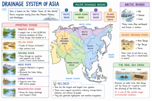
Drainage System
A drainage system refers to the network of rivers and their tributaries that collect and transport water from a region.
Asia’s drainage system is strongly influenced by:
- Relief and topography
- Monsoon rainfall
- Snow and glacier melt
- Tectonic uplift
- Climate zones
The Tibetan Plateau is particularly significant because it serves as the source region for several major rivers of South, Southeast, and East Asia.
The plateau stores vast quantities of water in the form of glaciers and snowfields. During summer, melting snow feeds rivers that support nearly half of humanity.
Created by ForumIAS
Major Lakes
Caspian Sea
Largest enclosed inland water body.
Lake Baikal
- Deepest freshwater lake in the world.
- Contains nearly 20% of global unfrozen freshwater.
Dead Sea
- Lowest exposed land point on Earth.
- Extremely saline.
Climate and Monsoon of Asia
Asia experiences the greatest climatic diversity in the world due to its vast size, varied relief, and strong oceanic influences. The continent includes everything from equatorial rainforests to polar tundra regions.
Major Factors Influencing Climate
- Latitude – Determines temperature zones from tropical to polar.
- Distance from Sea – Interior regions experience extreme temperatures, while coastal areas have moderate climates.
- Relief & Mountains – The Himalayas and other mountain ranges influence rainfall and temperature patterns.
- Ocean Currents – Affect coastal climates and precipitation.
- Monsoon Winds – Control seasonal rainfall across South and Southeast Asia.
- Tibetan Plateau – Influences pressure systems and monsoon circulation.
Monsoon System: Asia’s Climatic Backbone
Summer Monsoon
- Moisture-laden winds blow from sea to land.
- Brings heavy rainfall to India, Bangladesh, Myanmar, Thailand, Vietnam, and Southern China.
- Supports agriculture, hydropower, groundwater recharge, and river flow.
- Nearly 70–80% of India’s annual rainfall occurs during this season.
Winter Monsoon
- Winds reverse and blow from land to sea.
- Generally dry, but bring rainfall to Tamil Nadu after crossing the Bay of Bengal.
Role of Himalayas and Tibetan Plateau
- Himalayas block cold Central Asian winds and cause orographic rainfall.
- Tibetan Plateau, known as the “Heat Engine of the Asian Monsoon,” strengthens summer monsoon circulation.
Ocean Currents
Kuroshio Current
Warm current along Japan.
Oyashio Current
Cold current from the Bering Sea.
Their meeting creates one of the world’s richest fishing grounds.
North Equatorial Current
Influences Southeast Asian climate and tropical cyclones.
Natural Vegetation
Asia contains almost every vegetation type.
Tundra
Mosses and lichens dominate northern Siberia.
Taiga
Largest forest biome, consisting mainly of pine, spruce, and fir.
Temperate Mixed Forest
Found in China, Korea, and Japan.
Steppe Grasslands
Temperate grasslands of Central Asia.
Monsoon Forests
Dominated by teak, sal and bamboo.
Equatorial Rainforests
Located in Indonesia, Malaysia, and Borneo.
Desert Vegetation
Includes xerophytic plants and date palms.
Wildlife
Asia possesses remarkable biodiversity.
Important species include:
- Siberian Tiger
- Giant Panda
- Bengal Tiger
- Snow Leopard
- Orangutan
India supports the world’s largest tiger population, while China is home to the Giant Panda.
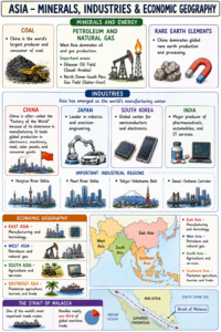
Natural Resources
Asia possesses abundant resources:
| Resource | Major Regions |
| Petroleum | Saudi Arabia, Iran, Iraq |
| Natural Gas | Qatar, Iran, Russia |
| Coal | China, India |
| Iron Ore | China, India |
| Rare Earths | China |
| Timber | Siberia |
| Fisheries | Japan, China |
West Asia contains more than half of the world’s petroleum reserves.
Agriculture
Agriculture remains the livelihood base of millions.
Rice Cultivation
Asia produces nearly 90% of global rice.
Major producers:
- China
- India
- Indonesia
- Vietnam
- Thailand
Wheat Cultivation
Important in:
- North China Plain
- Indo-Gangetic Plain
- Kazakhstan Steppes
Plantation Agriculture
Produces:
- Tea
- Rubber
- Coffee
- Palm Oil
Indonesia and Malaysia dominate palm oil production.
Fisheries
Asia has some of the world’s richest fishing grounds due to extensive coastlines and ocean currents.
Major fishing regions:
- Japan coast
- South China Sea
- East China Sea
China is the world’s largest producer of fish and aquaculture products.
Minerals and Energy
Created by ForumIAS
Transport and Trade
Railways
The Trans-Siberian Railway is the world’s longest railway line.
China possesses the world’s largest high-speed railway network.
Maritime Transport
Major ports include:
- Shanghai
- Singapore
- Shenzhen
- Hong Kong
Strategic Chokepoints
- Strait of Malacca
- Strait of Hormuz
- Bab-el-Mandeb
- South China Sea
These routes are crucial for world trade and energy security.
Asia’s enormous physical diversity, rich natural resources, monsoon climate, fertile river valleys, and dynamic economies have made it the center of global population, manufacturing, trade, and geopolitics. With rapid industrialization, technological advancement, and increasing regional integration, Asia is expected to play a decisive role in shaping the world’s economic and strategic future.
Prelims Questions
Q.1) Which one of the following countries has a market based steel industry?
(a) Germany
(b) England
(c) India
(d) Japan
U.P.P.S.C. (R.I.) 2014
Q.2) In West Asia, the highest Petroleum producing country is:
(a) Iraq
(b) Iran
(c) Saudi Arabia
(d) Lebanon
U.P. R.O./A.R.O. (Mains) 2017
Q.3) Asia’s biggest gold market is:
(a) Jakarta, Indonesia
(b) Beijing, China
(c) Kathmandu, Nepal
(d) Meerut, India
U.P. P.C.S. (Mains) 2017
Q.4) Which of the following continents has all types of climatic zones?
(a) South America
(b) North America
(c) Australia
(d) Asia
U.P.P.C.S. (Mains) 2016
Q.5) The strait which separates Asia from North America is—
(a) Bering Strait
(b) Palk Strait
(c) Strait of Gibraltar
(d) Strait of Malacca
U.P. Lower Sub. (Pre) 2004
Q.6) Lake Balkhash is situated in which one of the following countries?
(a) Kazakhstan
(b) Kyrgyzstan
(c) Russia
(d) Turkmenistan
U.P. R.O./A.R.O. (Mains) 2021
Q.7) With reference to Borneo Island, located in South East Asia, which of the following statements is / are true?
- It is divided among three countries.
- It has been formed due to volcano deposition.
Select the correct answer from the code given below.
Code:
(a) Both 1 and 2
(b) Only 1
(c) Neither 1 nor 2
(d) Only 2
U.P.P.C.S. (Pre) 2022
Expected Mains Questions
Q.1) Discuss the role of the Himalayas in shaping the climate, drainage, and human geography of Asia.
Q.2) How do ocean currents influence the climate and fisheries of East Asia? Explain with suitable examples.
Q.3) Explain the significance of strategic maritime chokepoints in Asia’s trade geography.