Study Approach
Start with the Big Picture
Begin by understanding Africa as a complete geographical system. Study the chapter in a logical sequence:
Location → Relief → Rivers & Lakes → Climate → Vegetation & Wildlife → Resources → Agriculture → Industries → Trade & Geopolitics
This flow helps you understand how physical geography influences climate, vegetation, human activities, economic development, and Africa’s growing global importance.
Major Study Blocks and What to Focus On
- Physical Geography Block
Focus on the relationship between:
- Plateau structure and relief
- Atlas Mountains and Rift Valley
- Mountains, lakes, deserts, and rivers
Understand conceptually:
- Why Africa is called the Plateau Continent.
- Formation and significance of the East African Rift Valley.
- How plateau relief influences river flow, waterfalls, and hydropower.
Memorize:
- Major plateaus
- Important mountains and peaks
- Major lakes and rivers
- Deserts and their locations
- Climate Block
Study climate through causes and effects.
Understand conceptually:
- Role of latitude and ITCZ.
- Influence of ocean currents.
- Relationship between relief and climate.
Memorize:
- Climatic regions and locations.
- Cold and warm ocean currents.
- Characteristics of Equatorial, Savanna, Sahel, Desert, Mediterranean, and Highland climates.
- Vegetation and Wildlife Block
Link vegetation directly with climate.
Understand:
- Why vegetation belts appear symmetrically around the Equator.
- Climate–Vegetation–Wildlife relationship.
Memorize:
- Major vegetation types.
- Big Five animals.
- Important wildlife regions.
- Economic Geography Block
Study resources sector-wise.
Minerals → Agriculture → Fisheries → Industries → Trade
Understand conceptually:
- Why mineral wealth is concentrated in certain regions.
- Strategic importance of cobalt, lithium, and rare earth elements.
- Importance of Suez Canal and AfCFTA.
Memorize:
- Leading producers of gold, diamonds, cocoa, cassava, cobalt, petroleum, etc.
- Important ports and transport corridors.
How to Read Each Block
For every topic ask three questions:
- Where is it located?
- Why is it important?
- What are its economic or environmental implications?
This approach automatically prepares both Prelims and Mains content.
Diagram-Based Preparation
Practice these diagrams repeatedly:
- Outline map of Africa
- Physiographic divisions
- East African Rift Valley
- Major rivers and lakes
- Climatic regions map
- Ocean currents map
- Vegetation belts map
- Mineral distribution map
A blank Africa map should become a regular revision tool.
Revision Strategy
Prepare one-page revision sheets for:
- Relief features
- Rivers and lakes
- Climate types
- Ocean currents
- Minerals
- Agriculture and industries
Create:
- Comparison tables
- Classification charts
- Location-based maps
- Cause-and-effect flowcharts
Use active recall by drawing Africa’s map from memory and labeling major features without referring to notes.
Important for Prelims
- Atlas Mountains
- Mount Kilimanjaro
- Rift Valley
- Lake Victoria, Tanganyika, Malawi
- Sahara, Kalahari, Namib
- Nile, Congo, Niger, Zambezi
- Ocean currents
- Big Five animals
- Mineral-producing countries
- Suez Canal
- AfCFTA
Important for Mains
- Africa as the Plateau Continent
- Rift Valley and geothermal potential
- Climate and vegetation relationship
- Desertification in the Sahel
- Strategic mineral resources
- Agriculture and food security
- Energy resources
- Suez Canal’s geopolitical importance
- Africa in the global energy transition
- Regional integration through AfCFTA
Africa
| Table Content |
| Physiographic Divisions |
| Major Deserts of Africa |
| Major Rivers and Drainage |
| Climate of Africa |
| Mineral Resource |
| Regional Integration and Emerging Importance of Africa |
Introduction, Location and Extent
- Africa is the second-largest continent after Asia, covering about 30.37 million sq. km, nearly 20% of the world’s land area.
- It extends from 37°N to 35°S latitude and 17°W to 51°E longitude.
- Africa is bounded by the Mediterranean Sea (north), Atlantic Ocean (west), Indian Ocean (east), and Southern Ocean (south).
- The Equator, Tropic of Cancer, and Tropic of Capricorn pass through the continent, contributing to diverse climatic conditions.
- Africa comprises 54 countries and has a population exceeding 1.5 billion.
- It is known as the “Plateau Continent” because most of its surface consists of elevated plateaus rather than extensive plains.
- The average elevation ranges between 600–750 metres above sea level.
- Coastal plains are generally narrow and discontinuous.
- Rivers flowing from plateaus create numerous waterfalls, rapids, and gorges.
- Major plateaus include:
- Ethiopian Plateau
- East African Plateau
- South African Plateau
- Katanga Plateau
- Jos Plateau
- The plateau structure significantly influences Africa’s drainage system, climate, and economic activities.
Physiographic Divisions
Africa can broadly be divided into four physiographic regions:
- Atlas Mountain Region
- Central Plateau Region
- East African Rift Valley System
- Coastal Plains
Atlas Mountains
The Atlas Mountains extend across Morocco, Algeria and Tunisia and were formed during the Alpine Orogeny. They stretch for nearly 2,500 km and their highest peak is Mount Toubkal (4,167 m) in Morocco. These mountains act as a climatic barrier separating the Mediterranean coast from the Sahara Desert.
Central Plateau Region of Africa
- The Central Plateau Region is the largest physiographic division of Africa.
- It is the primary reason Africa is called the “Plateau Continent.”
- The region consists mainly of ancient crystalline rocks and extensive tablelands.
- Its average elevation ranges between 600–750 metres above sea level.
- It extends across Central and Southern Africa.
- Major plateaus include:
- Katanga Plateau
- South African Plateau
- Jos Plateau
- Important basins within the region are:
- Congo Basin
- Chad Basin
- Kalahari Basin
- Major rivers such as the Congo, Niger, Zambezi, and Orange originate from or flow across these plateaus.
- Numerous waterfalls and rapids provide significant hydropower potential.
- The region is rich in gold, diamonds, copper, cobalt, and uranium.
- Extensive savanna grasslands support agriculture, livestock rearing, wildlife, and tourism.
East African Rift Valley
The East African Rift Valley is one of the world’s most significant geological structures and represents an active divergent boundary between the Nubian and Somali plates. Stretching about 6,900 km, it contains volcanoes, geothermal zones and several lakes. Kenya has emerged as a leading producer of geothermal energy due to this rift system.
Coastal Plains of Africa
- The Coastal Plains form the fourth major physiographic division of Africa.
- These plains are generally narrow and discontinuous, stretching along the Atlantic Ocean, Indian Ocean, Mediterranean Sea, and Red Sea coasts.
- They are broader along the Gulf of Guinea and narrower on the eastern and southern coasts.
- Major coastal regions include the Nile Delta, Guinea Coast, Somali Coast, and Mozambique Coastal Plain.
- Important ports such as Alexandria, Lagos, Mombasa, Durban, and Djibouti are located here.
- Fertile soils and favorable climate support dense populations.
- Agriculture, fishing, tourism, and industries are concentrated in these areas.
- The Niger Delta is rich in petroleum resources.
- Coastal plains play a crucial role in Africa’s economy and international trade.
Mountains and Lakes
Though Africa is largely plateau-dominated, several important mountains exist. Mount Kilimanjaro (5,895 m) in Tanzania is the highest peak in Africa and the highest free-standing mountain in the world. Other important ranges include the Drakensberg Mountains, Rwenzori Mountains and Ethiopian Highlands. Kilimanjaro contains three volcanic cones—Kibo, Mawenzi and Shira.
The Great Rift Valley contains numerous lakes:
- Lake Victoria – largest lake in Africa and source of the White Nile.
- Lake Tanganyika – second deepest freshwater lake in the world.
- Lake Malawi – noted for exceptional biodiversity.
- Lake Turkana – largest desert lake.
Lake Victoria is also the largest tropical lake in the world.
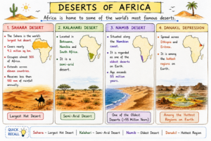
Major Deserts of Africa
| Desert / Region | Location | Key Feature |
| Sahara Desert | Extends across 11 countries in North Africa | World’s largest hot desert; covers about 9.2 million sq. km (nearly 30% of Africa); receives less than 100 mm rainfall annually. |
| Kalahari Desert | Botswana, Namibia, and South Africa | A semi-arid desert with sparse vegetation and grasslands. |
| Namib Desert | Along the Namibian coast | One of the oldest deserts on Earth, estimated to be over 55 million years old. |
| Danakil Depression | Ethiopia and Eritrea | Among the hottest regions on Earth, known for extreme temperatures and unique geological features. |
Created by ForumIAS
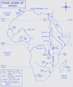
Major Rivers and Drainage
Africa’s plateau structure gives rise to many rivers and waterfalls. Major rivers include:
| River | Length | Mouth |
| Nile | 6,650 km | Mediterranean Sea |
| Congo | 4,700 km | Atlantic Ocean |
| Niger | 4,180 km | Gulf of Guinea |
| Zambezi | 2,574 km | Indian Ocean |
| Orange | 2,200 km | Atlantic Ocean |
Created by FourmIAS
Major Rivers of Africa
- Nile River
- Traditionally regarded as the world’s longest river.
- Formed by the confluence of the White Nile and Blue Nile at Khartoum (Sudan).
- The Blue Nile contributes about 80–85% of the floodwater.
- Supports Egypt, where nearly 95% of the population lives along the Nile Valley and Delta.
- The Aswan High Dam provides flood control and hydroelectric power.
- Congo River
- Africa’s second-longest and the world’s deepest river.
- Crosses the Equator twice.
- Ranks second after the Amazon in water discharge.
- The Inga Dam Project has huge hydropower potential.
- Niger River
- Vital river of West Africa.
- Forms a large inland delta in Mali.
- Zambezi River
- Famous for Victoria Falls.
- Hosts major hydropower projects such as Kariba Dam and Cahora Bassa Dam.
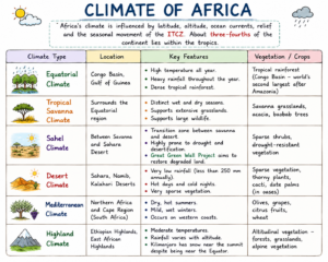
Climate of Africa
Africa’s climate is influenced by latitude, altitude, ocean currents, relief and the seasonal movement of the Inter-Tropical Convergence Zone (ITCZ). About three-fourths of the continent lies within the tropics.
Created by ForumIAS
Ocean Currents
Ocean currents strongly affect African climate.
- Canary Current (cold): causes aridity along northwest Africa.
- Benguela Current (cold): responsible for the Namib Desert and rich fisheries.
- Guinea Current (warm): brings moisture to West Africa.
- Mozambique Current and Agulhas Current (warm): influence southeastern Africa.
Natural Vegetation and Wildlife
Africa displays a symmetrical arrangement of vegetation belts.
Equatorial Rainforests
Centered on the Congo Basin, these forests contain mahogany, ebony and rubber trees and store enormous quantities of carbon.
Savanna Grasslands
Covering nearly half of Africa, these grasslands contain acacia and baobab trees and support livestock and wildlife tourism.
Steppe and Desert Vegetation
The Sahel contains drought-resistant shrubs, while desert regions support thorny plants and date palms around oases.
Mediterranean Vegetation
Olive, cork oak and citrus trees dominate the Mediterranean regions.
Wildlife
Africa is famous for its biodiversity. Major wildlife regions include Serengeti, Masai Mara, Okavango Delta and Virunga. The famous Big Five are:
- Lion
- Leopard
- Elephant
- Rhinoceros
- Buffalo
The annual migration of over 1.5 million wildebeest between Serengeti and Masai Mara is the world’s largest terrestrial animal migration.
Mineral Resource
| Mineral Resource | Major Producing Region/Country | Significance |
| Gold | Ghana | Ghana is Africa’s leading gold producer. |
| Diamonds | Botswana, South Africa (Kimberley) | Botswana leads diamond production by value; Kimberley gave rise to the term “Kimberlite Pipe”. |
| Copper | Zambia, DR Congo (Copper Belt) | The Copper Belt is one of the world’s richest copper-producing regions. |
| Cobalt | DR Congo | DR Congo contributes about 70% of global cobalt production; vital for EV batteries. |
| Uranium | Various African countries | Important source of fuel for nuclear energy generation. |
| Petroleum (Oil) | Nigeria, Libya, Algeria, Angola | Major contributors to Africa’s energy exports and economy. |
| Natural Gas | Egypt (Zohr Gas Field), Mozambique | Growing importance in global energy markets due to large gas reserves and discoveries. |
Agriculture
Agriculture employs a large proportion of Africa’s workforce.
Major food crops include:
- Maize
- Millet
- Sorghum
- Cassava
- Rice
Nigeria is the world’s largest producer of cassava. Plantation agriculture produces cocoa, coffee, tea, cotton and palm oil. Côte d’Ivoire and Ghana together account for more than 60% of global cocoa production.
Fisheries and Industries
Rich fisheries are associated with the Canary and Benguela Currents. Morocco is Africa’s leading fisheries exporter. Major industrial economies include South Africa, Egypt, Nigeria and Algeria.
South Africa possesses the continent’s most diversified industrial base, with industries ranging from mining and steel to automobiles and chemicals. Egypt’s industries are concentrated around the Nile Valley and Suez Canal Corridor.
Transport and Trade
The Trans-African Highway Network seeks to improve connectivity across the continent. Railways such as TAZARA connect Zambia with Tanzania. Major ports include:
- Durban (South Africa)
- Lagos (Nigeria)
- Alexandria (Egypt)
- Mombasa (Kenya)
- Djibouti
The Suez Canal, about 193 km long, carries nearly 12% of global trade and remains one of the world’s most important maritime chokepoints.
Regional Integration and Emerging Importance of Africa
- The African Continental Free Trade Area (AfCFTA) is the world’s largest free trade area by participation, covering 54 countries and over 1.4 billion people.
- AfCFTA aims to enhance intra-African trade, economic integration, and market connectivity.
- Africa possesses significant reserves of cobalt, lithium, manganese, and rare earth elements.
- These minerals are essential for electric vehicles, batteries, and renewable energy technologies.
- Africa’s geopolitical and economic importance is steadily increasing.
- Despite developmental challenges, Africa is expected to play a major role in the global economy and energy transition.
Prelims Questions
Q.1) In which of the following countries of Africa, dense, hot and humid forest are found?
(a) Ivory Coast
(b) Kenya
(c) Zimbabwe
(d) South Africa
U.P.P.C.S. (Pre) 1998
Q.2) Which one of the following is not pastoral nomads?
(a) Pygmies
(b) Kazaks
(c) Masai
(d) Lapps
U.P.P.C.S. (Pre) 2005
Q.3) Which region of the World, would you associate with “Bushmen”?
(a) East Africa
(b) Sahara Desert
(c) New Zealand
(d) Kalahari
U.P. Lower Sub. (Pre) 2008
Q.4) Which of the following pairs is not correctly matched?
(a) Fulani-West Africa
(b) Bantu-Sahara
(c) Masai-East Africa
(d) Nuba- Sudan
U.P.P.C.S.(Pre) 2012 U.P.U.D.A./L.D.A. (Spl) (Pre) 2010
Q.5) Match List – I with List – II and select the correct answer using the codes given below the lists:
List – I List – II
- Cocoa 1. Ivory Coast
- Coffee 2. Kenya
- Tea 3. South Africa
- Sugarcane 4. Ghana
Code:
A B C D
(a) 3 2 1 4
(b) 4 1 2 3
(c) 1 4 3 2
(d) 2 3 4 1
U.P. Lower Sub. (Pre) 2013
Q.6) The largest copper producing country in Africa is:
(a) South Africa
(b) Zambia
(c) Kenya
(d) Tanzania
U.P.U.D.A./L.D.A. (Spl) (Pre) 2010
Q.7) Postmasburg and its adjacent areas of South Africa is major producer of which of the following minerals?
(a) Uranium
(b) Bauxite
(c) Manganese
(d) Mica
U.P. P.C.S. (Pre) 2020
Expected Mains Questions
Q.1) Why is Africa known as the “Plateau Continent”? Describe its major physiographic divisions.
Q.2) Discuss the major climatic regions of Africa and examine the role of ocean currents in influencing its climate.
Q.3) “Africa is a continent of immense resource wealth but limited economic development.” Critically examine