Study Approach
Start with the big picture. Before memorizing facts, understand how the chapter progresses logically. Europe should be studied as a sequence: Location and Physiography → Drainage → Climate → Vegetation → Resources → Agriculture and Industries → Transport → European Union. This flow helps explain how physical geography influences economic development and regional integration.
How to Read Each Block
Block 1: Location and Physiography
Focus on understanding why Europe is called the “Peninsula of Peninsulas.” Connect physiographic divisions with human activities.
Memorize:
- Major peninsulas
- Major seas and straits
- Four physiographic divisions
- Highest peak (Mount Elbrus)
Understand:
- How the Northern European Plain supports dense population and agriculture.
- How the Alps influence climate and transport.
Prepare a classification table:
- Highlands
- Plains
- Uplands
- Alpine Mountains
Block 2: Drainage System
Study rivers through maps rather than isolated facts.
Memorize:
- River → Length → Mouth
- Major lakes and their locations
Understand:
- Why European rivers are highly navigable.
- Relationship between rivers, trade, industries, and urbanization.
Block 3: Climate and Ocean Currents
This is a highly conceptual section.
Memorize:
- Climatic regions
- North Atlantic Drift
- Norwegian Current
- Canary Current
Understand:
- Why Europe experiences moderate climate despite high latitude.
- Interaction among latitude, westerlies, ocean currents, and relief.
Practice climate-region mapping repeatedly.
Block 4: Vegetation and Resources
Study vegetation through climatic zones.
Memorize:
- Tundra
- Taiga
- Mixed Forest
- Steppe
- Mediterranean Vegetation
Understand:
- Climate–vegetation relationship.
- Economic significance of forests, grasslands, and fisheries.
Block 5: Agriculture, Industries and Transport
This block is application-oriented.
Memorize:
- Major industrial regions
- Major ports
- Coalfields and iron ore regions
- Important agricultural regions
Understand:
- Why the Ruhr became an industrial hub.
- Why Rotterdam is Europe’s leading port.
- How transport networks support economic growth.
Block 6: European Union
Study this as a geography-economy integration topic.
Memorize:
- Headquarters
- Members
- Currency
- Key benefits
Understand:
- Importance of regional integration.
- Economic and geopolitical significance of the EU.
Diagram-Based Preparation
Practice the following diagrams repeatedly:
- Europe political outline map
- Physiographic divisions map
- River and lake map
- Climatic regions map
- Natural vegetation map
- Mineral resource map
- Industrial regions map
- Major ports and transport network map
Important for Prelims
- Peninsulas, seas, straits
- Physiographic divisions
- River mouths
- Major lakes
- Climatic regions
- Ocean currents
- Coalfields and iron ore regions
- Major ports
- EU facts
Important for Mains
- Impact of physiography on development
- Importance of the Northern European Plain
- Role of rivers in trade and industrialization
- Influence of North Atlantic Drift
- Climate–vegetation relationship
- Resource distribution and industrial growth
- Transport connectivity and economic integration
- Significance of the European Union
EUROPE
| Table Content |
| Physiographic Divisions |
| Drainage System |
| Climate of Europe |
| Vegetation and Resources |
| Agriculture, Industries and Transport |
| European Union (EU) |
Europe is the second-smallest continent, covering about 10.18 million sq. km, yet it has played a dominant role in world history through the Renaissance, Industrial Revolution, scientific advancements, and modern democracy. Located in the western part of Eurasia, Europe is bounded by the Arctic Ocean in the north, Atlantic Ocean in the west, Mediterranean Sea in the south, and the Ural Mountains and Caspian Sea in the east. It accounts for about 7% of the world’s land area and comprises nearly 50 countries.
Europe: A Peninsula of Peninsulas
Europe is often called the “Peninsula of Peninsulas” because much of its land projects into surrounding seas. Major peninsulas include:
- Scandinavian Peninsula
- Iberian Peninsula
- Italian Peninsula
- Balkan Peninsula
- Jutland Peninsula
Its deeply indented coastline has greatly promoted maritime trade and navigation. Important seas include the Mediterranean Sea, North Sea, Baltic Sea, Black Sea, Norwegian Sea, and Barents Sea. Major straits include the Strait of Gibraltar, Bosporus, Dardanelles, and the English Channel.
Physiographic Divisions
Europe can be divided into four major physiographic regions:
- Northwestern Highlands
Composed of ancient crystalline rocks and heavily modified by glaciation. It includes Norway, Sweden, Scotland, Finland, and Iceland. Characteristic features include fjords, glacial valleys, lakes, and waterfalls. Sognefjord in Norway is the longest fjord in Europe.
- Northern European Plain
Stretching from France to Russia, it is Europe’s largest plain and contains fertile soils, dense population, industries, and major transport networks. Major crops include wheat, barley, sugar beet, and potatoes. Most European cities are concentrated here.
- Central Uplands
These are old eroded mountains rich in coal and iron ore. Important regions include the Black Forest (Germany), Massif Central (France), and Bohemian Massif (Czech Republic). They contributed significantly to Europe’s industrialization.
- Alpine Mountain System
These young fold mountains were formed during Alpine orogeny. Major ranges include:
- Alps
- Pyrenees
- Carpathians
- Apennines
- Dinaric Alps
- Caucasus Mountains
Mount Elbrus (5,642 m) in the Caucasus is the highest peak of Europe. The Alps act as a climatic barrier between northern and southern Europe.
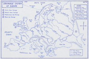
Drainage System
Europe possesses one of the world’s best-developed river networks. Rivers are highly navigable and support trade and industries.
Major Rivers
| River | Length | Mouth |
| Volga | 3,530 km | Caspian Sea |
| Danube | 2,850 km | Black Sea |
| Ural | 2,428 km | Caspian Sea |
| Dnieper | 2,201 km | Black Sea |
| Rhine | 1,230 km | North Sea |
| Rhône | 813 km | Mediterranean Sea |
| Po | 652 km | Adriatic Sea |
| Thames | 346 km | North Sea |
Important Rivers
Volga River
- Longest river in Europe.
- Lifeline of Russia.
- Important for irrigation and hydropower.
Danube River
- Most international river.
- Flows through or borders ten countries.
- Passes through four capitals: Vienna, Bratislava, Budapest, and Belgrade.
Rhine River
- Busiest waterway of Europe.
- Connects Germany’s industrial region to Rotterdam Port.
- Linked with Danube through the Rhine-Main-Danube Canal.
Created by ForumIAS
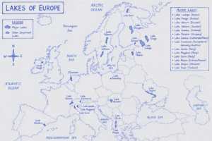
Major Lakes
Most lakes are glacial in origin.
- Lake Ladoga – largest lake in Europe.
- Lake Onega – second largest.
- Lake Vänern – largest lake in Sweden.
- Lake Saimaa – largest lake in Finland.
- Lake Geneva – shared by Switzerland and France.
- Lake Balaton – largest lake in Central Europe.
Created by ForumIAS
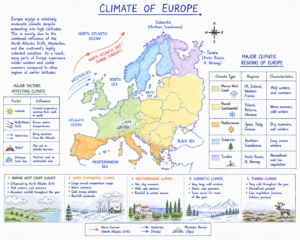
Climate of Europe
Despite its high latitude, Europe experiences moderate climate due to the influence of the North Atlantic Drift, westerlies, and maritime conditions.
Major Climatic Regions
- Marine West Coast Climate – UK, France.
- Humid Continental Climate – Poland, Ukraine.
- Mediterranean Climate – Spain, Italy, Greece.
- Subarctic Climate – Scandinavia.
- Tundra Climate – Arctic Russia and Northern Norway.
Created by ForumIAS
Ocean Currents
- North Atlantic Drift (Warm) – moderates climate.
- Norwegian Current (Warm) – keeps ports ice-free.
- Canary Current (Cold) – supports fisheries.
Without the North Atlantic Drift, Western Europe would experience severe winters similar to eastern Canada.
Vegetation and Resources
Natural Vegetation
Vegetation follows latitudinal zonation.
Tundra
Northernmost Europe; mosses and lichens dominate.
Taiga Forest
Coniferous forests of pine, spruce, and fir extending across Russia and Scandinavia. Important for timber and paper industries.
Mixed Forest
Contains both deciduous and coniferous trees and supports dense population and agriculture.
Steppe Grasslands
Found in Ukraine and southern Russia. Characterized by fertile Chernozem (Black Earth) soils. Ukraine is called the “Breadbasket of Europe.”
Mediterranean Vegetation
Consists of olive trees, cork oak, cypress, and vineyards. Portugal is the world’s leading producer of commercial cork.
Natural Resources and Minerals
Europe possesses coal, iron ore, petroleum, natural gas, timber, fisheries, and hydropower resources.
Coalfields
- Ruhr Coalfield (Germany)
- Upper Silesian Coalfield (Poland)
- Donets Basin (Ukraine)
- South Wales Coalfield (UK)
Iron Ore Regions
- Kiruna Mine (Sweden)
- Kursk Magnetic Anomaly (Russia)
- Kryvyi Rih (Ukraine)
Petroleum and Natural Gas
The North Sea is Europe’s major oil and gas basin.
Major producers:
- Norway
- United Kingdom
- Netherlands
Norway is now Europe’s largest supplier of natural gas.
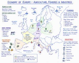
Agriculture, Industries and Transport
Agriculture
Europe practices highly mechanized, scientific, and commercial agriculture. Despite limited agricultural land, Europe remains one of the world’s leading agricultural producers due to advanced technology and efficient farming practices.
Created by ForumIAS
Industries
Europe is one of the world’s most industrialized regions.
Major Industrial Regions
| Region | Country | Industry |
| Ruhr | Germany | Steel and Engineering |
| Midlands | UK | Engineering |
| Paris Basin | France | Manufacturing |
| Po Valley | Italy | Automobiles and Textiles |
| Upper Silesia | Poland | Coal and Steel |
Germany is the industrial powerhouse of Europe and possesses the largest economy in the continent.
Transport Network
Europe has one of the world’s densest transport systems.
Railways
High-speed rail leaders:
- Spain
- France
- Germany
Eurotunnel
Connects Britain and France through a 50 km undersea tunnel.
Inland Waterways
- Rhine River – busiest waterway.
- Danube River – connects Central Europe.
- Rhine-Main-Danube Canal links the North Sea with the Black Sea.
Maritime Trade
Europe’s indented coastline supports extensive maritime trade.
Major Ports
- Rotterdam (Netherlands) – largest port in Europe.
- Antwerp (Belgium)
- Hamburg (Germany)
- Marseille (France)
Rotterdam is known as the “Gateway to Europe.”
European Union (EU)
The European Union represents the most advanced form of regional economic integration.
- Member States: 27
- Population: ~450 million
- Headquarters: Brussels
- Common Currency: Euro (€)
Benefits include:
- Free movement of goods and people.
- Common market.
- Economic cooperation.
- Promotion of green technologies and renewable energy.
Europe’s moderate climate, fertile plains, navigable rivers, mineral resources, and advanced transportation network have made it one of the most developed regions of the world. Despite its small size, Europe remains a global center of manufacturing, finance, technology, trade, and regional integration, with the European Union playing an important role in shaping the continent’s economic and geopolitical importance.
Prelims Questions
Q.1) Which one of the following countries has a market based steel industry?
(a) Germany
(b) England
(c) India
(d) Japan
U.P.P.S.C. (R.I.) 2014
Q.2) In West Asia, the highest Petroleum producing country is:
(a) Iraq
(b) Iran
(c) Saudi Arabia
(d) Lebanon
U.P. R.O./A.R.O. (Mains) 2017
Q.3) Asia’s biggest gold market is:
(a) Jakarta, Indonesia
(b) Beijing, China
(c) Kathmandu, Nepal
(d) Meerut, India
U.P. P.C.S. (Mains) 2017
Q.4) Which of the following continents has all types of climatic zones?
(a) South America
(b) North America
(c) Australia
(d) Asia
U.P.P.C.S. (Mains) 2016
Q.5) The strait which separates Asia from North America is—
(a) Bering Strait
(b) Palk Strait
(c) Strait of Gibraltar
(d) Strait of Malacca
U.P. Lower Sub. (Pre) 2004
Q.6) Lake Balkhash is situated in which one of the following countries?
(a) Kazakhstan
(b) Kyrgyzstan
(c) Russia
(d) Turkmenistan
U.P. R.O./A.R.O. (Mains) 2021
Q.7) With reference to Borneo Island, located in South East Asia, which of the following statements is / are true?
- It is divided among three countries.
- It has been formed due to volcano deposition.
Select the correct answer from the code given below.
Code:
(a) Both 1 and 2
(b) Only 1
(c) Neither 1 nor 2
(d) Only 2
U.P.P.C.S. (Pre) 2022
Expected Mains Questions
Q.1) Discuss the role of the Himalayas in shaping the climate, drainage, and human geography of Asia.
Q.2) How do ocean currents influence the climate and fisheries of East Asia? Explain with suitable examples.
Q.3) Explain the significance of strategic maritime chokepoints in Asia’s trade geography.