Study Approach
Start with the big picture: Begin by understanding the overall structure of India’s coastline before studying individual coastal regions. Follow the sequence: Extent of the Coastline → Eastern Coastal Plain → Western Coastal Plain → Comparison → Types of Coastlines → Significance. This logical flow helps you connect physical features with economic activities, biodiversity, and strategic importance.
Study Block 1: India’s Coastal Plains – Overview
How to Read This Block
Start with the location, extent, and division of India’s coastline. Understand why the Peninsular Plateau is flanked by two coastal plains and how their geological origin differs.
What to Memorize
- Total coastline length
- Eastern and Western Coastal Plains
- States covered
- General width and extent
What to Understand
- Why the Eastern Coastal Plain is broader.
- Why the Western Coastal Plain is narrow.
- Influence of relief and rivers on coastal formation.
Study Block 2: Eastern Coastal Plain
Study the Eastern Coastal Plain in three regional units:
- Utkal Coast
- Andhra Coast
- Coromandel Coast
How to Read This Block
- Location
- Major rivers
- Important deltas
- Lagoons
- Important ports and islands
- Agricultural significance
Focus Areas
Understand why this coast is known as an emergent coast and why it contains large deltas.
Study Block 3: Western Coastal Plain
Study each subdivision separately:
- Kathiawar Coast
- Konkan Coast
- Kannada Coast
- Malabar Coast
How to Read This Block
For every coastal division, learn:
- Extent
- Characteristic landforms
- Important lakes and backwaters
- Natural harbours
- Special geographical features
Study Block 4: Comparison and Coastal Processes
- Western Coastal Plain
- Eastern Coastal Plain
Also understand:
- Emerged coastline
- Submerged coastline
Study Block 5: Significance of India’s Coastline
- Agriculture
- Trade and Ports
- Mineral Resources
- Blue Economy
- Tourism
- Biodiversity
Relate every significance to current affairs wherever possible.
Diagram-Based Preparation
- Outline map showing:
- Eastern Coastal Plain
- Western Coastal Plain
- Major coastal divisions
- Map showing:
- Chilika Lake
- Pulicat Lake
- Vembanad Lake
- Rann of Kutch
- Sriharikota
- Major ports
- Flowchart:
Eastern Coast → Utkal → Andhra → Coromandel - Flowchart:
Western Coast → Kathiawar → Konkan → Kannada → Malabar - Comparison table:
Western Coast vs Eastern Coast
Important for Prelims
- Coastal divisions and their locations
- Major lagoons and lakes
- Important deltas
- Natural harbours
- Sriharikota, Gir Forest, Rann of Kutch
- Emerged and submerged coastlines
- Ramsar sites along the coast
- Major ports and coastal states
Important for Mains
- Comparison of Eastern and Western Coastal Plains
- Formation of coastal landforms
- Coastal processes and geomorphology
- Economic significance of India’s coastline
- Blue Economy and maritime trade
- Coastal biodiversity and conservation
- Climate change, coastal erosion, and disaster management
COASTAL PLAINS
| Table Content |
| Eastern Coastal Plain |
| Western Coastal Plain |
| Coastline |
| Significance of Coastline |
COASTAL PLAINS
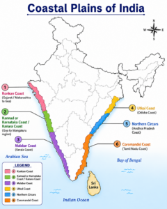
India is endowed with a vast coastline of 7,516.6 km, including about 1,197 km of island coastline belonging to the Andaman & Nicobar Islands and Lakshadweep Islands. On either side of the Peninsular Plateau lie two narrow strips of lowland known as the Eastern Coastal Plain and the Western Coastal Plain
Created by ForumIAS
Eastern Coastal Plain
- The Eastern Coastal Plain is a broad alluvial plain situated between the Eastern Ghats and the Bay of Bengal.
- It extends from the Ganga Delta in the north to Kanyakumari in the south.
- The plain has been formed by the deposition of alluvial sediments brought by major rivers such as the Mahanadi, Godavari, Krishna, and Cauvery.
- Regionally, it is known by different names, namely the Utkal Coast in Odisha, the Andhra Coast to its south, and the Coromandel Coast, which comprises the coastal regions of southern Andhra Pradesh and Tamil Nadu.
- Important lagoons located along this coast include Chilika Lake and Pulicat Lake.
- The Eastern Coast is an emergent coast and is considerably wider than the Western Coastal Plain.
- The stretch between the Mahanadi and Krishna Rivers is known as the Northern Circars, while the region between the Krishna and Cauvery Rivers is called the Carnatic Plain.
Utkal Plain
- The Utkal Plain comprises the coastal region of Odisha along with the Mahanadi Delta.
- It contains Chilika Lake, the largest brackish water lagoon in India.
Andhra Plain
- The Andhra Plain lies south of the Utkal Plain and extends up to Pulicat Lake.
- The Godavari and Krishna Rivers form extensive deltas in this region, which have merged to create a single large deltaic tract.
- Owing to its relatively straight coastline, the region lacks many natural harbours, although Visakhapatnam and Machilipatnam serve as important exceptions.
- Sriharikota Island, situated near Pulicat Lake, hosts the Satish Dhawan Space Centre, India’s principal space launch facility.
Tamilnadu Plain (Coromandel Coast)
- The Tamilnadu Plain extends from Pulicat Lake to Kanyakumari.
- The Cauvery River forms a highly fertile delta in this region.
- It is regarded as one of the most productive agricultural regions of South India.
Western Coastal Plain
- The Western Coastal Plain is a narrow coastal strip lying between the Arabian Sea and the Western Ghats.
- It extends from the Gulf of Khambhat (Cambay) in Gujarat to Kanyakumari.
- The average width of this plain is about 50 km, making it much narrower than the Eastern Coastal Plain.
- The coast extends across Gujarat, Maharashtra, Goa, Karnataka, and Kerala.
- Based on regional characteristics, it is divided into the Kathiawar Coast, Konkan Coast, Kannada Coast, and Malabar Coast.
- Vembanad Lake, the longest lake in India, is situated along the Malabar Coast.
Kathiawar Coastal Plain
- The Kathiawar Coastal Plain includes the Kutch and Kathiawar Peninsulas, which, despite being geological extensions of the Peninsular Plateau, are generally treated as parts of the Western Coastal Plain.
- The Great Rann of Kutch is a vast saline coastal plain located north of the Kutch Peninsula, while its southern extension is known as the Little Rann of Kutch.
- Mount Girnar, the highest point of the region, is of volcanic origin.
- South of the Kathiawar Peninsula lies the Gir Forest, the only natural habitat of the Asiatic Lion.
Konkan Coastal Plain
- The Konkan Coast extends from Daman and Diu to Goa.
- It is characterized by submergence and erosional landforms.
- The Thane Creek near Mumbai, designated as a Ramsar Site, forms an important estuarine embayment and natural harbour.
Karnataka Coastal Plain (Kannada Coast)
- The Kannada Coast extends from Goa to Mangaluru and is a narrow, highly indented coastal strip.
- The famous Jog Falls (Gersoppa Falls) on the Sharavati River is located in this region.
- Numerous lagoons and backwaters occur along this coast.
Malabar Coastal Plain
- The Malabar Coast extends from Mangaluru to Kanyakumari.
- It is wider than the Karnataka Coast and is characterized by an extensive network of lakes, lagoons, estuaries, and backwaters (Kayals).
- Vembanad Lake, the longest lake in India, is located along this coast.
- The backwater system of Kerala is one of the most distinctive physiographic features of the Malabar Coast.
Difference Between the Western Coastal Plain and Eastern Coastal Plain
| Western Coastal Plain | Eastern Coastal Plain |
| Lies between the Western Ghats and the Arabian Sea. | Lies between the Eastern Ghats and the Bay of Bengal. |
| Extends from the Gulf of Khambhat to Kanyakumari. | Extends from the Ganga Delta to Kanyakumari. |
| Runs parallel to the Western Ghats. | Runs parallel to the Eastern Ghats. |
| Contains both submerged and emerged coastal features. | Predominantly an emerged coast. |
| Comparatively narrow and elongated. | Comparatively broader and wider. |
| Divided into Kathiawar, Konkan, Kannada, and Malabar Coasts. | Divided into Utkal, Andhra, and Coromandel Coasts. |
| Rivers generally form estuaries and do not develop large deltas. | Rivers form extensive and well-developed deltas. |
| Possesses several natural harbours such as Kandla, JNPT, Mormugao, Mangaluru, and Kochi. | Comparatively fewer natural harbours and ports. |
Coastline
A coastline is the boundary where land meets the sea or ocean. It is a dynamic zone continuously shaped by the action of waves, tides, currents, rivers, and tectonic processes. Coastlines may be emerged or submerged and support rich biodiversity, human settlements, ports, agriculture, fisheries, and diverse economic activities.
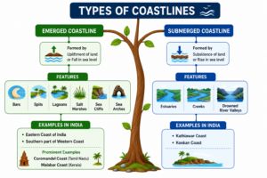
Types of Coastlines
Emerged Coastline: An emerged coastline develops due to the upliftment of land or fall in sea level. Characteristic features of such coastlines include bars, spits, lagoons, salt marshes, sea cliffs, and sea arches. The Eastern Coast of India and the southern part of the Western Coast are examples of emerged coastlines. Prominent examples include the Coromandel Coast of Tamil Nadu and the Malabar Coast of Kerala.
Submerged Coastline: A submerged coastline is formed due to the subsidence of land or rise in sea level. Such coasts are characterized by estuaries, creeks, and drowned river valleys. The Kathiawar Coast and Konkan Coast of the Western Coastal Plain are examples of submerged coastlines.
Created by ForumIAS
Significance of Coastline
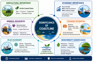
Agricultural Importance: The fertile coastal plains support extensive cultivation of rice, coconut, sugarcane, spices, and plantation crops, making them important agricultural regions of India.
Economic Importance: Major and minor ports situated along the coastline handle nearly 95% of India’s trade by volume and around 70% by value, making the coast crucial for international trade and commerce.
Mineral Resources: Coastal tracts contain significant deposits of Monazite Sand, an important source of Thorium, with Kerala possessing the largest reserves. Coastal sedimentary basins are also rich in petroleum, natural gas, and shale gas resources.
Tourism Potential: The beaches of Maharashtra, Goa, Kerala, Tamil Nadu, and Odisha, along with Kerala’s famous backwaters, attract large numbers of domestic and international tourists and contribute significantly to the tourism sector.
Blue Economy: Fishing, aquaculture, shipping, offshore energy production, and maritime trade provide livelihoods to millions of people living in coastal regions and form an important component of India’s Blue Economy.
Biodiversity Significance: Coastal ecosystems such as mangroves, estuaries, coral reefs, lagoons, mudflats, and seagrass beds support rich biodiversity and play a vital role in ecological conservation and disaster mitigation.
Created by ForumIAS
Prelims Questions
Q.1) Which of the following States of India has the longest
coastline?
(a) Maharashtra
(b) Andhra Pradesh
(c) Kerala
(d) Gujarat
U.P. P.C.S. (Pre) 2018
Q.2) The northern part of the western Coastal Plain of India is also known as :
(a) Karnataka Coast
(b) Malabar
(c) Konkan
(d) Coromandel
U.P.P.C.S.(Pre) 2016
Expected Mains Questions
Q.1) Describe the major physiographic features of the Coastal Plains of India.
Q.2) Discuss the regional divisions of the Western Coastal Plain. How do they differ in terms of geomorphology and economic significance?
Q.3) Differentiate between emerged and submerged coastlines with suitable examples.