Study Approach
Start with the big picture: Begin by understanding the overall physiography of the Peninsular Plateau before studying its individual parts. Follow the sequence: Origin and geological structure → Boundaries and relief → Major hill ranges → Major plateaus → Deccan Plateau → Significance.
Study Block 1: Origin and General Characteristics
How to Read This Block
Focus on the origin, age, geological stability, boundaries, slope, and drainage of the plateau. Understand why it is called the oldest landmass of India and how its geology differs from the Himalayas.
What to Memorize
- Shape and extent
- Average elevation
- General slope (west to east)
- Eastward and westward flowing rivers
- Geological composition
What to Understand
- Why most rivers flow eastward.
- Why Narmada and Tapi flow westward.
- Difference between the Peninsular Plateau and the Himalayan region.
Study Block 2: Major Hill Ranges
Study the hill ranges one by one:
- Aravalli
- Vindhya
- Satpura
- Western Ghats
- Eastern Ghats
How to Read This Block
For every hill range, prepare the same framework:
- Location
- Extent
- Highest peak
- Rivers originating
- Special geographical features
- Importance
Study Block 3: Major Plateaus
- Central Highlands
- Malwa
- Bundelkhand
- Chotanagpur
- Meghalaya
- Dandakaranya
- Deccan Plateau
Focus Areas
Connect every plateau with:
- Geological structure
- Drainage
- Soil
- Mineral resources
- Economic importance
Study Block 4: Deccan Plateau
Study:
- Boundaries
- Drainage
- Maharashtra Plateau
- Karnataka Plateau
- Telangana Plateau
Study Block 5: Significance of the Peninsular Plateau
- Mineral resources
- Agriculture
- Biodiversity
- Hydroelectric power
- Tourism
Always relate physical geography with economic importance.
Diagram-Based Preparation
- Outline map showing:
- Aravalli
- Vindhya
- Satpura
- Western Ghats
- Eastern Ghats
- Map showing:
- Major plateaus
- Important rivers
- Highest peaks
- Flowchart:
Origin → Relief → Drainage → Resources → Significance
Important for Prelims
- Hill ranges and highest peaks
- Major passes
- River origins
- Plateau divisions
- Mineral locations
- Black Soil and Deccan Trap
- Western Ghats Biodiversity Hotspot
Important for Mains
- Geological evolution of the Peninsular Plateau
- Physiographic divisions
- Drainage pattern
- Mineral distribution
- Western Ghats and Eastern Ghats comparison
- Economic significance of the plateau
- Role in agriculture, hydropower, biodiversity, and sustainable development
THE PENINSULAR PLATEAU
| Table Content |
| Origin and Characteristics |
| Major Hill Ranges |
| The Western Ghats |
| The Eastern Ghats |
| Major Plateaus of the Peninsular Region |
| The Deccan Plateau |
| Significance of the Peninsular Plateau |
Origin and Characteristics
The Peninsular Plateau stands as one of the most ancient and geologically stable landmasses on Earth, forming the heartland of the Indian subcontinent. Roughly triangular in shape, it is part of the primordial Gondwanaland and is composed predominantly of Archaean gneisses, schists, granites, and other crystalline rocks that have endured billions of years of geological history. Its antiquity sets it apart from the relatively young Himalayas, making it a region of exceptional scientific and geographical significance.
Bounded by the Northern Plains in the north, the Delhi Ridge in the northwest, the Rajmahal Hills in the east, the Gir Range in the west, and the Western and Eastern Ghats along its southwestern and southeastern flanks, the plateau covers nearly 16 lakh square kilometres. Its average elevation ranges between 600 and 900 metres above sea level, and its general slope runs from west to east, which explains why most Peninsular rivers—including the Godavari, Krishna, Cauvery, and Mahanadi—drain eastward into the Bay of Bengal. Significant exceptions are the Narmada and Tapi rivers, which flow westward through faulted rift valleys and empty into the Arabian Sea.
Major Hill Ranges
Aravalli Range
Among the oldest fold mountain systems in the world, the Aravalli Range stretches approximately 800 km from Delhi in the northeast to Ahmedabad in Gujarat in the southwest, passing through Haryana, Rajasthan, and Gujarat. Guru Shikhar (1,722 m) on Mount Abu is its highest peak. The Aravallis serve as the source of important rivers including the Banas, Luni, and Sabarmati. Notably, the Great Boundary Fault separates the Aravalli Range from the Vindhyan Range to its east.
Vindhyan Range
The Vindhyan Range, formed primarily as block mountains through faulting associated with the Narmada Rift Valley, extends more than 1,200 km in an east–west direction and includes the Vindhyachal Hills, Bhander Hills, Kaimur Hills, and Parasnath Hills. With an average elevation between 300 and 650 metres, the Vindhyas function as a crucial watershed separating the Ganga Basin from the river systems of Peninsular India.
Satpura Range
Running nearly 900 km between the Narmada Valley in the north and the Tapi Valley in the south, the Satpura Range is a tectonic mountain system formed through folding and upliftment. Its major subdivisions — the Mahadeo Hills, Maikal Range, and Rajpipla Hills – contain Dhupgarh (1,350 m) near Pachmarhi as the highest peak. The sacred plateau of Amarkantak (1,127 m) in the Maikal Hills serves as the source of both the Narmada and Son rivers.
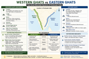
The Western Ghats
Known also as the Sahyadris, the Western Ghats form the steep western edge of the Peninsular Plateau and run parallel to the Arabian Sea coastline for nearly 1,600 km, from the Tapti Valley to Kanyakumari. They are India’s second most prominent mountain system and are globally recognized as a UNESCO World Heritage Site and one of the world’s Biodiversity Hotspots.
The northern section, concentrated in Maharashtra, has an average elevation of around 1,200 metres and gives rise to the Godavari, Bhima, and Krishna rivers. Key passes include Thal Ghat (Mumbai–Nashik) and Bhor Ghat (Mumbai–Pune). The middle section, through Goa and Karnataka, includes peaks like Kudremukh and Pushpagiri, and the important Palghat Gap- the largest break in the Western Ghats — separates the Nilgiri Hills from the Annamalai Hills. In the southern section, Anamudi (2,695 m) in the Annamalai Hills rises as the highest peak of Peninsular India. The Cardamom Hills and Agasthyamalai Hills, at the southernmost extent, are celebrated for extraordinary biodiversity and endemic species.
The Eastern Ghats
The Eastern Ghats define the eastern boundary of the Peninsular Plateau and run discontinuously and in a dissected manner along the Bay of Bengal coast, stretching from the Mahanadi Valley in Odisha to the Vaigai Basin in Tamil Nadu. Unlike the Western Ghats, they are fragmented by major rivers including the Mahanadi, Godavari, Krishna, and Cauvery. Jindhagada Peak (1,690 m) in the Araku region is their highest point. Further south, the Eastern Ghat reappear as the Nallamala Range and ultimately merge with the Western Ghats in Tamil Nadu.
Created by ForumIAS
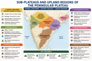
Major Plateaus of the Peninsular Region
The Peninsular Plateau encompasses a diverse set of sub-plateaus and upland regions, each with distinct geology, topography and drainage characteristics.
- Central Highlands (Madhya Bharat Plateau): Situated north of the Vindhyan Range and drained by the Chambal River system; noted for the famous Chambal Ravines caused by severe gully erosion.
- Malwa Plateau: A triangular plateau bounded by the Aravallis, Madhya Bharat Plateau, and Bundelkhand Plateau, with dual drainage flowing toward both the Arabian Sea and the Bay of Bengal. It is covered largely by fertile black soil.
- Bundelkhand Plateau: Composed of ancient Bundelkhand Gneiss and drained by the Betwa, Dhasan, and Ken rivers; characterized by an undulating, intensely weathered landscape.
- Chotanagpur Plateau: Covering most of Jharkhand and parts of West Bengal and Chhattisgarh, this plateau is India’s premier mineral belt, rich in coal, iron ore, bauxite, mica, and uranium. The Damodar River flows through it in a rift valley.
- Meghalaya Plateau: The northeastern extension of the Peninsular Plateau, comprising the Garo, Khasi, and Jaintia Hills, separated from the main block by the Garo–Rajmahal Gap (Malda Gap).
- Dandakaranya Plateau: A heavily forested upland drained by the Mahanadi and Godavari, extending across Chhattisgarh, Odisha, and Andhra Pradesh.
Created by ForumIAS
The Deccan Plateau
The Deccan Plateau is the largest physiographic unit of the Peninsular region, occupying the vast interior of southern India. Bounded by the Vindhya–Satpura system in the north and the Western and Eastern Ghats on either side, its average elevation is around 600 metres and its general slope is from west to east. Major rivers such as the Godavari, Krishna, Cauvery, and Mahanadi drain this extensive plateau into the Bay of Bengal.
The Maharashtra Plateau in the north is defined by its basaltic lava-derived Black Cotton Soil (Regur Soil) and characteristic trap topography from ancient Deccan volcanic eruptions. The Karnataka Plateau (Mysore Plateau), with its highest point at Mullayanagiri (1,930 m), is divided into the forested Malnad region and the gentler Maidan plains. The Telangana Plateau, composed of Dharwar rocks and rich in minerals, is drained by the Godavari, Krishna, and Pennar systems.
Significance of the Peninsular Plateau
The Peninsular Plateau is of immense national importance across multiple dimensions:
- Mineral Wealth: Nearly 98% of India’s Gondwana coal deposits lie within the plateau. Vast reserves of iron ore, manganese, bauxite, mica, copper, uranium, and limestone make it India’s mineral heartland.
- Agriculture: Fertile black soils support large-scale cotton cultivation. Hill regions sustain plantation crops such as coffee, tea, spices, and rubber.
- Biodiversity and Forests: The plateau supports extensive evergreen, deciduous, and thorn forests, and harbours exceptional wildlife across its protected areas.
- Hydroelectric Power: Rivers cascading from the Western Ghats offer significant hydroelectric potential, supporting several major power projects.
- Tourism: Renowned hill stations including Ooty, Mahabaleshwar, Pachmarhi, Khandala, Matheran, and Coorg attract millions of visitors annually.
The Peninsular Plateau represents the geological foundation of India – ancient, stable, and resource-rich. Its diverse sub-regions, hill ranges, river systems, and mineral deposits continue to shape the economic and ecological character of the subcontinent.
Expected Mains Questions
Q.1) Discuss the origin and major characteristics of the Peninsular Plateau of India.
Q.2) Highlight the significance of the Western Ghats in terms of biodiversity, climate, and river systems.
Q.3) Describe the geographical characteristics and economic importance of the Chotanagpur Plateau.