Study Approach
Start with the big picture: Do not begin by memorizing Bhabar, Terai, Bhangar, and Khadar separately. First understand the overall logic of the Northern Plains:
Formation of Northern Plains → Physiographic Divisions → Regional Divisions → Significance
Once you understand how Himalayan rivers deposit sediments from north to south and how different regions developed.
Study Block 1: Physiographic Divisions of the Northern Plain
Focus on the north-to-south sequence:
Bhabar → Terai → Bhangar → Khadar → Delta
How to Read This Block
For every division, study the same parameters:
- Location
- Type of sediments
- Water conditions
- Fertility
- Agriculture
- Special features
What to Memorize
- Width of Bhabar and Terai
- Coarse sediments in Bhabar
- Re-emergence of rivers in Terai
- Kankar in Bhangar
- Annual renewal of Khadar
- Chars and Bils in Delta
What to Understand
- Why streams disappear in Bhabar.
- Why Terai is marshy.
- Why Khadar is more fertile than Bhangar.
- How river deposition changes from foothills to delta.
Study Block 2: Regional Divisions of Northern Plains
Study the plains region-wise:
- Rajasthan Plain
- Punjab–Haryana Plain
- Ganga Plain
- Brahmaputra Plain
How to Read This Block
For every region focus on:
- Formation
- Rivers
- Relief features
- Agriculture
- Special geographical characteristics
Important Concepts
- Doabs in Punjab
- Delhi Ridge as a divider
- Ganga Plain subdivisions
- Braided channels in Brahmaputra
- Chars and Majuli Island
- Kosi River and channel shifting
Study Block 3: Ganga Plain Subdivisions
Focus on:
- Regional characteristics
- Cropping patterns
- Flood behaviour
- River dynamics
Study Block 4: Significance of Northern Plains
This section is highly useful for Mains.
Study under four dimensions:
- Population
- Agriculture
- Industry
- Culture
Try linking geography with economy, society, transport, and settlement patterns.
Diagram-Based Preparation
Practice these diagrams repeatedly:
- North-South cross-section:
Shivalik → Bhabar → Terai → Bhangar → Khadar → Delta - Map of regional divisions:
- Rajasthan Plain
- Punjab-Haryana Plain
- Ganga Plain
- Brahmaputra Plain
- Ganga Plain subdivision map:
- Upper
- Middle
- Lower
- Flowchart:
River deposition → Landform formation → Soil characteristics → Agriculture
Important for Prelims
- Bhabar vs Terai
- Bhangar vs Khadar
- Kankar, Reh, Kallar, Thur, Bhur
- Chars and Bils
- Doabs
- Majuli Island
- Kosi River
- Delhi Ridge
Important for Mains
- Physiographic significance of Northern Plains
- River deposition and landform development
- Agricultural importance
- Floods and river dynamics
- Human settlement and economic development
- Regional variations within Northern Plains
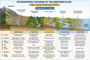
Physiographic Division of the Northern Plain
| Table Content |
| Physiographic Division |
| Regional Division of the Northern Plains |
| Regional Subdivisions of the Ganga Plain |
| Significance of the Northern Plains |
Physiographic Division
Based on the nature, age, and depositional characteristics of sediments, the Indus–Ganga–Brahmaputra Plain is divided into the following physiographic belts from north to south:
- Bhabar Plain
- Terai Plain
- Bhangar Plain
- Khadar Plain
- Delta Plain
Bhabar Plain
The Bhabar is the northernmost belt of the Northern Plain, located immediately south of the Shivalik Foothills. It is a narrow strip, about 6–8 km wide, formed by the deposition of coarse materials such as boulders, gravels, pebbles, and sand carried by Himalayan rivers. Its width is greater in the west and decreases eastward. Due to highly porous deposits, streams disappear underground, making the region generally unsuitable for agriculture.
Terai Plain
The Terai lies immediately south of the Bhabar region and forms a broad belt about 15–30 km wide. Rivers that disappear in the Bhabar re-emerge here, creating marshy and waterlogged conditions. The region is characterized by poor drainage, dense forests, swamps, and rich biodiversity. Its soils are rich in nitrogen, humus, and organic matter, making them highly fertile for crops such as rice, sugarcane, and wheat, while also supporting wildlife like tigers, elephants, and one-horned rhinoceroses.
Bhangar Plain
Bhangar refers to the older alluvial deposits found on elevated terraces above the active floodplains and beyond the reach of annual floods. Since these deposits are not regularly renewed, they are older than Khadar. Bhangar soils often contain Kankar (calcium carbonate nodules) and may develop saline patches called Reh, Kallar, or Thur. Other notable features include Bhur deposits in the Ganga–Yamuna Doab and the Barind Tract of West Bengal. The soils are generally dark, clayey, and rich in organic matter.
Khadar Plain
Khadar consists of newer alluvial deposits laid down annually by rivers during floods and is found in the active floodplains along river banks. Due to continuous renewal, Khadar soils are extremely fertile and highly suitable for agriculture, making the region one of India’s most productive farming areas. Major crops include rice, wheat, sugarcane, jute, pulses, and vegetables. In Punjab, these floodplains are known as Bet Lands (Bets) and also support wetlands, grasslands, and diverse wildlife habitats.
Delta Plain
The Delta Plain is the lowermost extension of the Khadar region near river mouths, formed by the deposition of fine sediments where rivers enter seas or oceans. It consists of old and new mud, marshes, tidal flats, and distributary channels. In deltaic areas, elevated landforms are called Chars, while low-lying marshy depressions are known as Bils. The Ganga–Brahmaputra (Sundarbans) Delta, the world’s largest delta, is highly fertile and supports intensive agriculture, fisheries, and dense human settlements.
Created by ForumIAS
Regional Division of the Northern Plains
Based on geographical characteristics, climatic conditions, drainage patterns, and regional variations, the Northern Plains are divided into the following major regions:
- Rajasthan Plain
- Punjab–Haryana Plain
- Ganga Plain
- Brahmaputra Plain
Rajasthan Plain
The Rajasthan Plain is an undulating plain with an average elevation of about 325 metres, largely occupied by the Thar Desert (Great Indian Desert). It has developed mainly through the depositional activities of the Indus River System and its ancient tributaries. The presence of gneiss, granite, and crystalline rocks reflects its connection with the Peninsular Plateau. The Bagar Region forms a semi-arid transition zone between the Thar Desert and the Aravalli Range. The region is drained by seasonal streams, while the Luni River flows southwestward into the Rann of Kutch. Sand dunes, wind action, and sparse vegetation are its characteristic features.
Punjab–Haryana Plain
The Punjab–Haryana Plain has been formed by the depositional activities of the Indus River System. Punjab, meaning “Land of Five Rivers”—Jhelum, Chenab, Ravi, Beas, and Sutlej – is characterized by numerous Doabs, or tracts of land between two rivers. The plain is bounded by the Shivalik Range, Yamuna River, and Thar Desert, while the Delhi Ridge separates it from the Ganga Plain. Saline patches called Reh or Kallar occur in drier areas. Owing to fertile alluvial soils, extensive irrigation, and the Green Revolution, it has become one of India’s most productive agricultural regions.
The Ganga Plain
The Ganga Plain is the largest subdivision of the Northern Plains, extending about 1,400 km from west to east with an average width of nearly 300 km. It stretches from the Yamuna Basin in the west to the Bangladesh border in the east. The plain has been formed by the alluvial deposits of the Ganga and its tributaries, along with contributions from Peninsular rivers such as the Chambal, Betwa, Ken, and Son. Owing to its fertile soils and abundant water resources, it is among the world’s most productive agricultural regions.
The Upper Ganga Plain
The Upper Ganga Plain comprises the Ganga–Yamuna Doab, Rohilkhand, Awadh, and parts of the Agra Division. The region has a general slope towards the east and south-east and is characterized by fertile alluvial soils and extensive irrigation facilities. It witnessed significant success during the Green Revolution, particularly in western Uttar Pradesh. As a result, it has become a highly productive agricultural region, with wheat, sugarcane, rice, and oilseeds being the principal crops.
The Middle Ganga Plain
The Middle Ganga Plain covers Central and Eastern Uttar Pradesh and extends into Northern Bihar up to Muzaffarpur. It is characterized by thick alluvial deposits and a relatively lower occurrence of Kankar. Due to the region’s gentle gradient, rivers frequently meander and change their courses. The Kosi River, known as the “Sorrow of Bihar,” is particularly famous for its channel shifting and destructive floods. Prominent geomorphic features include floodplains, oxbow lakes, and wetlands.
The Lower Ganga Plain
The Lower Ganga Plain extends from Patna to the Bay of Bengal. In this region, the Ganga River turns southward before entering the sea. The plain is highly prone to seasonal flooding and is rich in Khadar (new alluvial deposits), which enhance soil fertility. Major economic activities include rice cultivation, jute farming, aquaculture, and inland fisheries. Towards the east, the region gradually merges into the Ganga–Brahmaputra Delta, one of the world’s most fertile deltaic regions.
Regional Subdivisions of the Ganga Plain
The Ganga Plain is further divided into the following regional units:
○ Rohilkhand Plain
○ Awadh Plain
○ Mithila Plain
○ Magadh Plain
The Brahmaputra Plain
- The Brahmaputra Plain, also known as the Assam Plain or Assam Valley, forms the easternmost segment of the Northern Plains.
- It extends from the Lower Ganga Plain in the west to the Purvanchal Hills in the east.
- This plain has been formed by the depositional activities of the Brahmaputra River and its numerous tributaries.
- Due to the very gentle gradient and enormous sediment load, the Brahmaputra exhibits a highly braided channel pattern.
- The river frequently forms riverine islands known as Chars.
- Majuli, located in Assam, is one of the world’s largest inhabited river islands.
- The fertile alluvial soil supports extensive cultivation of rice, jute, tea, and mustard.
- Frequent floods and riverbank erosion are common features of this region.
- The Ganga–Brahmaputra Delta, the largest delta in the world, is protected by the mangrove forests of the Sundarbans.
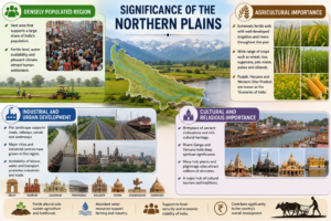
Significance of the Northern Plains
Densely Populated Region
- The Northern Plains occupy nearly one-fourth of India’s geographical area but support almost half of the country’s population.
- Fertile soils, abundant water resources, and favourable climatic conditions have encouraged dense human settlement.
Agricultural Importance
- The region possesses fertile alluvial soils, extensive irrigation networks, and perennial river systems.
- Major crops grown include wheat, rice, sugarcane, jute, maize, pulses, and oilseeds.
- Due to high agricultural productivity, Punjab, Haryana, and Western Uttar Pradesh are often referred to as the “Granaries of India.”
Industrial and Urban Development
- The flat terrain has facilitated the development of extensive networks of roads, railways, canals, and inland waterways.
- Several major industrial and urban centres such as Delhi, Kanpur, Lucknow, Prayagraj, Varanasi, Patna, Kolkata, Chandigarh, and Guwahati are located in this region.
- Easy availability of labour, water, and transport facilities has promoted industrialization.
Cultural and Religious Importance
- The Northern Plains have been the cradle of several ancient civilizations and cultural traditions.
- Numerous important pilgrimage centres are located along the banks of the Ganga and Yamuna.
- Major religious centres include Haridwar, Prayagraj, Varanasi, Gaya, Mathura, Vrindavan, Kurukshetra, and Amritsar.
- The region continues to be a major centre of cultural tourism and religious activities.
Created by ForumIAS
Prelims Questions
Q.1) Which one of the following is the most productive soil
in India?
(a) Red soil
(b) Black soil
(c) Alluvial soil
(d) Calcareous soil
U.P.R.O./A.R.O. (Pre) 2014
Q.2) ‘Moribund Delta’ is a sub-division of which of the
following Delta ?
(a) Krishna-Godawari Delta
(b) Mahanadi Delta
(c) Bengal Delta
(d) Cauvery Delta
U.P.P.C.S. (Pre) 2019
Expected Mains Questions
Q.1) Explain the physiographic divisions of the Northern Plains. How do differences in depositional processes influence their characteristics?
Q.2) Differentiate between Bhangar and Khadar on the basis of origin, fertility, agricultural significance, and geomorphic features.
Q.3) Describe the geomorphological characteristics of the Brahmaputra Plain. Why is it highly prone to floods and riverbank erosion?