Study Approach
Start with the big picture: Study this chapter as a connected geographical story rather than a collection of facts. Follow the sequence: Location & Extent → Physiography → Drainage → Great Lakes → Climate → Vegetation → Agriculture → Minerals & Energy → Industries → Contemporary Importance. This approach helps you understand how physical geography influences economic development.
How to Read Each Block
Location and Physiography:
Begin with the continent’s position, boundaries, and major physical divisions. Focus on the four physiographic regions—Western Cordilleras, Great Plains, Central Lowlands, and Appalachian Highlands. Understand their location and significance rather than merely memorizing names.
Drainage and Great Lakes:
Study rivers through a simple framework: Source → Drainage → Importance. Pay special attention to the Mississippi-Missouri system, Mackenzie, Yukon, Colorado, and Columbia rivers. For the Great Lakes, remember the acronym HOMES and understand their role in transportation, trade, and industrial growth.
Climate and Vegetation:
Link climate with latitude, relief, and ocean currents. Understand how the Rockies create rain-shadow effects and how climate determines vegetation patterns such as tundra, taiga, prairies, and deciduous forests.
Agriculture, Minerals, and Industries:
Study regional specialization. Connect agricultural belts, mineral regions, and industrial centres with the physical environment and resource availability.
Diagram-Based Preparation
Practice drawing a rough outline map of North America and repeatedly mark:
- Rocky Mountains and Appalachians
- Great Plains
- Mississippi-Missouri system
- Great Lakes
- Gulf Stream and Labrador Current
- Major mineral and petroleum regions
Important for Prelims
- Denali, Greenland, Bering Strait
- Rocky Mountains and Appalachians
- Mississippi and Missouri rivers
- Great Lakes (HOMES)
- Gulf Stream and Labrador Current
- Canadian Shield
- Alberta Oil Sands
- USMCA
Important for Mains
- Relationship between relief, climate, and economic activities
- Significance of the Great Lakes region
- Resource-based industrialization
- Arctic warming and geopolitical importance
- Energy transition and critical minerals
NORTH AMERICA
Introduction, Location and Extent
- North America is the third-largest continent after Asia and Africa, covering about 24.7 million sq. km.
- It includes Canada, the USA, Mexico, Greenland, and several Caribbean islands.
- The continent extends from the Arctic Ocean in the north to Central America in the south.
- It lies entirely in the Northern Hemisphere, between 7°N–83°N latitude and 20°W–170°W longitude.
- It is bounded by the Arctic Ocean (north), Atlantic Ocean (east), Pacific Ocean (west), and Caribbean Sea & Panama Isthmus (south).
- The Bering Strait separates North America from Asia and was historically connected through the Bering Land Bridge.
- Important water bodies include the Gulf of Mexico, Hudson Bay, Labrador Sea, and Caribbean Sea.
- The continent’s strategic location between the Atlantic and Pacific Oceans supports global trade.
- Rich natural resources, fertile plains, mountains, forests, and advanced industries make it one of the world’s most influential economic regions.
- Arctic sea routes and critical mineral resources are increasing its geopolitical importance.
| Feature | Details |
| Area | 24.7 million sq. km |
| Largest Country | Canada |
| Most Populous Country | USA |
| Highest Peak | Denali (6190 m) |
| Largest Island | Greenland |
| Largest Lake | Lake Superior |
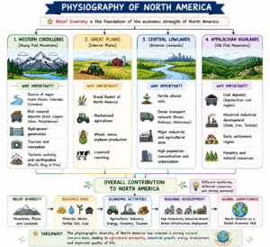
Physiographic Divisions of North America
North America is divided into four major physiographic regions: Western Cordilleras, Great Plains, Central Lowlands, and Appalachian Highlands. These regions have greatly influenced the continent’s population distribution, agriculture, industries, and transport networks.
- Western Cordilleras extend from Alaska to Central America and include the Rocky Mountains, Sierra Nevada, Cascade Range, and Coast Mountains. Rich in minerals such as gold, copper, and silver, the region supports mining, forestry, tourism, and hydropower. As part of the Pacific Ring of Fire, it is prone to earthquakes and volcanic activity. The mountains also create rain-shadow effects by blocking moist Pacific winds.
- Great Plains, located east of the Rockies, consist of fertile prairie grasslands. Known as the Bread Basket of North America, they support large-scale mechanized farming of wheat, maize, and soybeans, along with extensive cattle ranching.
- Central Lowlands form the economic heartland of the continent. Drained by the Mississippi-Missouri river system, they possess fertile alluvial soils, navigable waterways, major industries, and dense transportation networks.
- Appalachian Highlands are among the world’s oldest fold mountains. Rich coal deposits contributed significantly to the industrialization of the United States and the growth of manufacturing centres.
- Together, these physiographic regions form the foundation of North America’s agricultural productivity, mineral wealth, and industrial development.
Created by ForumIAS
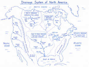
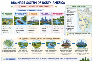
Drainage System and Major Rivers
Created by FourmIAS
- North America has a well-developed drainage system shaped by its diverse relief and climate.
- Rivers originate from the Rocky Mountains, Appalachian Highlands, and Canadian Shield and drain into the Arctic, Atlantic, Pacific Oceans, and the Gulf of Mexico.
- The Mississippi-Missouri River System is the most important, draining nearly one-third of the continent and supporting agriculture, transportation, and settlement.
- The Mackenzie River is the largest Arctic-draining river and an important transport route in Canada.
- The Yukon River is historically linked with gold mining.
- The Colorado River carved the Grand Canyon and is crucial for irrigation, hydropower, and water supply.
- North American rivers play an important role in navigation, industry, urban growth, and economic development.
| Major River | Source Region | Drains Into | Importance |
| Mississippi | Lake Itasca | Gulf of Mexico | Navigation, Agriculture |
| Missouri | Rocky Mountains | Mississippi River | Longest river in North America |
| Mackenzie | Great Slave Lake | Arctic Ocean | Arctic Drainage |
| Yukon | British Columbia | Bering Sea | Gold Mining |
| Colorado | Rocky Mountains | Gulf of California | Grand Canyon |
| Columbia | Rockies (Canada) | Pacific Ocean | Hydropower |
Created by ForumIAS
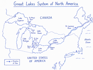
The Great Lakes Region
Created by ForumIAS
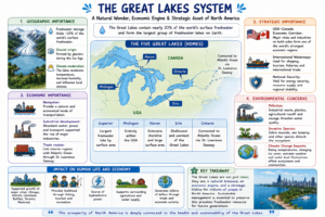
- The Great Lakes System is one of North America’s most important geographical features, containing nearly 20% of the world’s surface freshwater.
- Formed by glacial activity during the Ice Age, the lakes greatly influenced settlement, transportation, and industrial growth.
- The five lakes are remembered by the acronym HOMES—Huron, Ontario, Michigan, Erie, and Superior.
- Lake Superior is the world’s largest freshwater lake by surface area.
- The lakes are connected to the Atlantic Ocean through the St. Lawrence Seaway.
- The region became an industrial hub due to abundant freshwater, transport facilities, and raw materials.
- Major concerns include pollution, invasive species, and climate change.
| Lake | Key Characteristic |
| Superior | Largest freshwater lake by area |
| Michigan | Entirely within USA |
| Huron | Extensive shoreline |
| Erie | Shallowest Great Lake |
| Ontario | Connected to Atlantic Ocean |
Created by ForumIAS
Climate of North America
- North America experiences almost all major climatic types due to its vast latitudinal extent and varied relief.
- Climate is influenced by latitude, altitude, ocean currents, prevailing winds, and mountain barriers.
- The Rocky Mountains create rain-shadow conditions by blocking moist Pacific winds.
- The Gulf Stream (warm), Labrador Current, and California Current (cold) significantly affect regional climates.
- Tundra and Sub-Arctic climates occur in the north, while Humid Continental climates dominate the east.
- Mediterranean climate in California and Steppe climate in the Great Plains support specialized agriculture and economic activities.
| Climate Type | Major Region |
| Tundra | Greenland, Arctic Canada |
| Sub-Arctic | Northern Canada |
| Humid Continental | Eastern USA & Southern Canada |
| Mediterranean | California |
| Steppe | Great Plains |
| Desert | Southwestern USA |
| Tropical | Caribbean & Southern Mexico |
Natural Vegetation and Biodiversity
- North America has diverse vegetation due to its varied climate.
- The Arctic region supports Tundra vegetation of mosses, lichens, and dwarf shrubs.
- South of it lies the Taiga Forest Belt, dominated by pine, spruce, and fir trees.
- The Prairie Grasslands of the Great Plains are highly productive agricultural regions.
- Eastern North America contains deciduous forests, while the Pacific coast has temperate rainforests with redwoods and Douglas fir.
- Major biodiversity hotspots include California, Mesoamerica, and the Caribbean.
- Deforestation, urbanization, invasive species, and climate change threaten these ecosystems.
Agriculture and Economic Activities
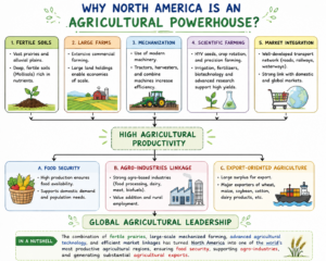
- North America has one of the world’s most advanced and productive agricultural systems.
- Large farms, mechanization, biotechnology, scientific farming, and modern irrigation have greatly increased productivity.
- Major agricultural regions include the Corn Belt (maize), Wheat Belt (wheat), Dairy Belt (milk products), and Cotton Belt (cotton).
- Canada is a leading producer of wheat, canola, and pulses, while Mexico specializes in fruits, vegetables, and horticulture.
- Agriculture is closely linked with agro-processing industries and export markets.
- Fertile soils, favourable climate, technology, and infrastructure drive success, though water scarcity, soil degradation, and climate change remain key challenges.
Created by ForumIAS
Mineral Resources and Energy Potential
- North America is one of the world’s most resource-rich continents and possesses abundant mineral and energy resources.
- The Canadian Shield contains iron ore, nickel, copper, gold, uranium, and zinc. The Sudbury Basin is famous for nickel, while the Mesabi Range is known for iron ore.
- The Cordilleran region contains copper, gold, silver, molybdenum, and rare earth elements, while Mexico is a major silver producer.
- Important petroleum regions include Texas, Alaska, the Gulf of Mexico, Alberta Oil Sands, and the Permian Basin.
- Critical minerals such as lithium, cobalt, nickel, and rare earths are increasingly important for renewable energy and electric vehicles.
| Resource | Major Region |
| Iron Ore | Labrador, Mesabi Range |
| Nickel | Sudbury Basin |
| Copper | Arizona, British Columbia |
| Gold | Alaska, Nevada |
| Uranium | Saskatchewan |
| Petroleum | Texas, Alaska, Alberta |
| Natural Gas | Gulf Coast, Western Canada |
| Hydropower | Canada, Pacific Northwest |
Industrial Development
- North America is one of the world’s most industrialized regions due to abundant resources, technology, capital, skilled labour, and advanced infrastructure.
- The Great Lakes Region developed as the traditional manufacturing hub, with cities like Detroit, Chicago, Cleveland, and Buffalo.
- The Northeastern Manufacturing Belt remains important for finance, biotechnology, and advanced industries.
- Silicon Valley leads in information technology and innovation, while the Texas Gulf Coast specializes in petrochemicals.
- North America’s industrial growth increasingly depends on knowledge, research, and technological innovation.
Contemporary Relevance
- North America is gaining strategic importance due to Arctic warming, critical mineral demand, and renewable energy expansion.
- Arctic sea routes and resource exploration are becoming increasingly significant.
- Key challenges include climate change, water scarcity, ecosystem degradation, and supply-chain security.
- The USMCA continues to strengthen regional economic integration and trade.
Prelims Questions
Q.1) Which one of the following continents was not a part
of Gondwana Land?
(a) North America
(b) South America
(c) Africa
(d) Australia
U.P.P.C.S. (Mains) 2016
Q.2) ‘Death Valley’ situated in South California in the U.S.A
is an example of which of the following ?
(a) Anticlinal Valley
(b) Indian Valley
(c) Pristiclinal Valley
(d) Rift Valley
U.P.P.C.S. (Pre) 2012
Q.3) Which one of the following Country is geographically
located in America but politically is a part of Europe?
(a) Iceland
(b) Canary Iceland
(c) Greenland
(d) Cuba
U.P.P.C.S. (Pre) 2002
Q.4) Which one of the following continents has no
landlocked country?
(a) Africa
(b) Asia
(c) Europe
(d) North America
U.P.P.C.S. (Mains) 2005
Q.5) Which of the following lakes is located entirely within
the United States?
(a) Michigan
(b) Superior
(c) Ontario
(d) Erie
U.P. P.C.S. (Mains) 2017
Q.6) The strait which separates Asia from North America is—
(a) Bering Strait
(b) Palk Strait
(c) Strait of Gibraltar
(d) Strait of Malacca
U.P. Lower Sub. (Pre) 2004
Q.7) Soo Canal connects –
(a) Turan & Ontario
(b) Bengal & Tripura
(c) Superior & Michigan
(d) Superior & Huron
U.P.P.C.S. (Pre) 1991
Q.8) To which of the following racial groups the natives of
North America belong ?
(a) Austric
(b) Caucasoid
(c) Mongoloid
(d) Negroid
U.P.P.C.S. (Pre) 2015
Expected Mains Questions
Q.1) How have the Rocky Mountains influenced climate and economic activities?
Q.2) Discuss the role of the Great Lakes in the industrial and economic development of North America.
Q.3) Examine the factors responsible for climatic diversity in North America.