
The Peninsular Drainage System forms the backbone of southern India’s river network and is crucial for understanding India’s physical geography. This article explains the origin, characteristics, drainage patterns, major east- and west-flowing rivers, tributaries, important dams, river valleys, estuaries and deltas, inter-state water disputes, and recent developments. It also highlights how the ancient geological structure of the Peninsular Plateau has shaped these rivers and their significance for agriculture, irrigation, hydroelectric power, biodiversity, and sustainable water management.
The Peninsular Drainage System
| Table Content |
| Major Characteristics of Peninsular Rivers |
| East-Flowing Peninsular Rivers |
| West-Flowing Peninsular Rivers |
| Inter-State River Water Disputes |
The Peninsular Drainage System is the oldest river system of India, associated with the ancient and stable Peninsular Plateau, which was once part of the Gondwanaland Supercontinent. Unlike the youthful Himalayan Rivers, Peninsular rivers flow over hard igneous and metamorphic rocks and have evolved through millions of years of weathering, tectonic uplift, faulting, and erosion. These geological processes have created plateaus, rift valleys, waterfalls, residual hills, and broad river valleys.
Most Peninsular rivers flow eastward into the Bay of Bengal, forming extensive deltas. However, the Narmada and Tapi are notable exceptions, flowing westward through rift valleys into the Arabian Sea, where they form estuaries instead of deltas. The major rivers of this system are Mahanadi, Godavari, Krishna, Kaveri, Narmada, and Tapi.
Major Characteristics of Peninsular Rivers
The Peninsular rivers possess several distinct geographical features:
- Ancient Origin: They are older than the Himalayan rivers and have attained the mature stage of geomorphic development.
- Seasonal Nature: Most rivers depend mainly on the Southwest Monsoon and experience reduced discharge during the dry season.
- Stable Courses: Flow through hard rocky terrain with well-defined and fixed channels.
- Smaller Drainage Basins: Compared to Himalayan rivers, they have shorter lengths and smaller catchment areas.
- Limited Meandering: Resistant rocks restrict lateral erosion, resulting in fewer meanders.
- Distinct Drainage Patterns: Common patterns include Trellis, Radial, and Rectangular drainage.
- Waterfalls and Rapids: The uneven plateau surface creates numerous waterfalls, making these rivers important sources of hydroelectric power.
East-Flowing Peninsular Rivers
Nearly 80% of Peninsular rivers drain into the Bay of Bengal. The major east-flowing rivers are Mahanadi, Godavari, Krishna, and Kaveri, all of which form fertile deltas and support agriculture, industries, and settlements.
- Mahanadi River System
The Mahanadi is the third-largest Peninsular river after the Godavari and Krishna.
Origin and Course
- Originates near Sihawa Hills in Chhattisgarh.
- Flows through Chhattisgarh and Odisha before entering the Bay of Bengal.
- Total length: 851 km.
Major Tributaries
- Seonath
- Hasdeo
- Mand
- Ib
- Tel
Importance
The fertile Mahanadi basin supports cultivation of rice, pulses, and oilseeds. The famous Hirakud Dam, one of the world’s longest earthen dams, provides irrigation, flood control, and hydroelectric power. The river forms a fertile delta in Odisha and is central to water-sharing discussions between Odisha and Chhattisgarh.
- Godavari River System
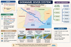
The Godavari is the longest Peninsular river and is popularly known as the “Dakshin Ganga”.
Created by ForumIAS
Importance
The basin supports cultivation of rice, cotton, sugarcane, pulses, and oilseeds. Major projects include the Sriram Sagar Project and the Polavaram Multipurpose Project, which provide irrigation, drinking water, hydropower, and flood control. The Godavari–Krishna Water Transfer Project is an important component of India’s river-linking programme. The river is also culturally significant, as the Kumbh Mela is held at Nashik on its banks.
- Krishna River System
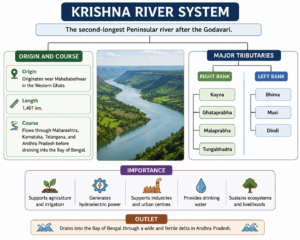
The Krishna River is the second-longest Peninsular river after the Godavari.
Created by ForumIAS
Importance
The Krishna basin is an important source of irrigation, hydroelectric power, and drinking water. Major projects include Nagarjuna Sagar, Srisailam, Almatti, Koyna, and Tungabhadra Dam. The river also forms part of National Waterway-4 and is associated with periodic inter-state water disputes among Maharashtra, Karnataka, Telangana, and Andhra Pradesh.
- Kaveri (Cauvery) River System
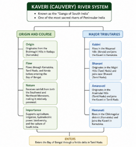
The Kaveri, known as the “Ganga of South India”, is one of the most sacred rivers of Peninsular India.
Created by ForumIAS
Importance
The Kaveri Delta, often called the “Rice Bowl of Tamil Nadu”, supports cultivation of rice, sugarcane, banana, coconut, and pulses. Major irrigation projects include the Krishnaraja Sagar (KRS) Dam, Mettur Dam, and Kabini Reservoir. The Shivanasamudra Hydroelectric Project, one of India’s earliest hydroelectric stations, is located on this river. The basin also supports rich biodiversity, including Nagarahole National Park, Bandipur Tiger Reserve, Mudumalai Tiger Reserve, and Sathyamangalam Tiger Reserve.
Important Small East-Flowing Rivers
Several smaller rivers also contribute significantly to eastern India’s drainage.
- Subarnarekha: Originates from the Ranchi Plateau and forms an estuary instead of a delta.
- Brahmani: Formed by the confluence of the South Koel and Shankh rivers; contributes to the Bhitarkanika Mangrove Ecosystem.
- Nagavali: Flows through Odisha and Andhra Pradesh, supporting irrigation.
- Vamsadhara: Important interstate river between Odisha and Andhra Pradesh, with the Vamsadhara Multipurpose Project.
West-Flowing Peninsular Rivers
Unlike east-flowing rivers, west-flowing rivers have shorter courses, flow through rift valleys, and generally form estuaries.
Narmada
- Originates from the Amarkantak Plateau.
- Flows between the Vindhya and Satpura Ranges.
- Important projects: Sardar Sarovar, Indira Sagar, Omkareshwar, and Bargi Dam.
- The Statue of Unity is located on its banks.
Tapi (Tapti)
- Originates near Multai (Madhya Pradesh).
- Flows parallel to the Narmada through a rift valley.
- Major project: Ukai Dam.
Other West-Flowing Rivers
- Luni: Largest river of the Thar Desert, terminating in the Rann of Kutch.
- Sabarmati: Associated with Sabarmati Ashram and the Sabarmati Riverfront Project.
- Mahi: Unique because it crosses the Tropic of Cancer twice.
Why Do West-Flowing Rivers Form Estuaries Instead of Deltas?
Most west-flowing rivers such as the Narmada and Tapi form estuaries because:
- They have shorter courses.
- They carry less sediment due to hard rocky terrain.
- They flow through steep gradients.
- The Western Coastal Plain is narrow.
- The western coast is a submerged coastline, favouring estuary formation instead of delta development.
Inter-State River Water Disputes
Growing demand for water has led to several inter-state river disputes. The constitutional framework is provided under Article 262 and the Inter-State River Water Disputes Act, 1956. The Inter-State River Water Disputes (Amendment) Bill, 2019 proposes a Permanent Tribunal and a Dispute Resolution Committee for faster settlement.
Major disputes include:
- Cauvery: Karnataka–Tamil Nadu–Kerala–Puducherry
- Krishna: Maharashtra–Karnataka–Telangana–Andhra Pradesh
- Mahanadi: Odisha–Chhattisgarh
- Mahadayi: Goa–Karnataka–Maharashtra
- Ravi–Beas: Punjab–Haryana–Rajasthan
- Vamsadhara: Andhra Pradesh–Odisha
The Peninsular Drainage System reflects the ancient geological evolution and structural stability of the Indian Peninsula. Rivers such as the Godavari, Krishna, Mahanadi, Kaveri, Narmada, and Tapi are indispensable for agriculture, irrigation, hydroelectric power, industry, biodiversity, and urban water supply. However, increasing water demand, climate change, and inter-state disputes highlight the need for integrated river basin management, efficient water use, and sustainable conservation to ensure long-term water security and balanced regional development.
Prelims Questions
Q.1) Assertion (A) : The rivers of Western Ghats do not form the delta.
Reason (R) : They flow through short courses with high speed over hard-rocks.
Select the correct answer from the codes given below:
Code :
a) Both (A) and (R) are correct, and (R) is the correct explanation of (A)
b) Both (A) and (R) are correct, but (R) is not the correct explanation of (A)
c) (A) is true, but (R) is false
d) (A) is false, but (R) is true
U.P.P.C.S. (Pre) 2014
Q.2) Assertion (A) : While all major rivers of peninsular India flow into the Bay of Bengal, the
Narmada and the Tapi flow into the Arabian sea.
Reason : (R) : The Narmada and the Tapi rivers flow in a rift valley.
Select the correct answer using the codes given below:
Code :
a) Both (A) and (R) are true, and (R) is the correct explanation of (A).
b) Both (A) and (R) are true, but (R) is not the correct explanation of (A).
c) (A) is true, but (R) is false.
d) (A) is false, but (R) is true.
U.P.P.C.S. (Mains) 2002
U.P.P.C.S. (Pre) 1999
Q.3) Which of these west flowing rivers flows between two mountain ranges?
a) Sharavati
b) Narmada
c) Mahi
d) Sabarmati
U.P.P.C.S.(Pre) 2012
Q.4) Assertion (A) : The Narmada forms a delta at its mouth.
Reason (R) : It flows through a rift valley.
Select the correct answer from the codes given below:
Code :
a) Both (A) and (R) are true, and (R) is the correct explanation of (A)
b) Both (A) and (R) are true, but (R) is not the correct explanation of (A)
c) (A) is true, but (R) is false
d) (A) is false, but (R) is true
U.P.P.C.S. (Mains) 2005
Q.5) The source of Cauvery River lies in –
a) Sahyadri
b) Brahmagiri Hills
c) Gavaligarh Hills
d) Amarkantak
U.P.R.O./A.R.O. (Mains) 2013
U.P.P.C.S. (Mains) 2011
Q.6) Which one of the following rivers is called the Ganga of the South ?
a) Cauvery
b) Krishna
c) Godavari
d) Narmada
U.P.P.C.S. (Pre) 2015
Q.7) The rivers of South India mainly have which of the following drainage patterns ?
a) Radial
b) Intermittent
c) Dendritic
d) Trellis
U.P.P.C.S. (Pre) 2014
Q.8) Which of the following rivers has the largest catchment area?
a) Narmada
b) Cauvery
c) Godavari
d) Krishna
U.P.P.C.S. (Pre) 2009
Expected Mains Questions
Q.1) Discuss the major characteristics of the Peninsular Drainage System. How do these characteristics distinguish it from the Himalayan Drainage System?
Q.2) Why do most Peninsular rivers flow eastward while the Narmada and Tapi flow westward? Explain the geological factors responsible for this drainage pattern.
Q.3) Why do the Narmada and Tapi rivers form estuaries instead of deltas? Explain with suitable geographical reasons.
Q.4) Discuss the economic significance of the major Peninsular rivers in the development of southern and central India.