Study Approach
Start with the big picture.
Study South America as a connected geographical system rather than a collection of isolated facts. Follow the chapter in a logical sequence: Location and Physical Features → River Basins and Rainforest → Climate → Resources and Economy → Strategic Importance. This flow helps you understand how relief influences climate, climate influences vegetation and agriculture, and natural resources shape economic and geopolitical importance.
Major Study Blocks
- Physical Geography and Landforms
Focus on the relationship between the Andes, Central Lowlands, and Eastern Highlands.
- Understand how the Andes were formed and why they are important.
- Learn the location and significance of major features such as the Amazon Basin, Orinoco Basin, La Plata Basin, Pampas, and Patagonia.
- Memorize major peaks, rivers, plateaus, and grasslands.
- River Systems and Amazon Rainforest
Study this block as a geography-environment linkage.
- Understand why the Amazon is the world’s largest river basin.
- Focus on the ecological role of the Amazon Rainforest.
- Learn causes and impacts of deforestation.
- Connect rivers with economic activities, settlements, and hydroelectric projects.
- Climate
Do not memorize climate types randomly.
- Understand how latitude, altitude, ocean currents, and the Andes influence climate.
- Link each climate type with its corresponding region.
- Pay special attention to the Humboldt Current, Brazil Current, and rain-shadow effect.
- Resources, Agriculture and Economy
Study resources region-wise.
- Memorize major minerals and producing countries.
- Understand why the Lithium Triangle is strategically important.
- Link agricultural regions with climatic conditions and soil characteristics.
- Relate industrial development to resource availability and urban centres.
- Strategic Significance
This is the most important analytical section for Mains.
- Focus on biodiversity, climate regulation, food security, freshwater resources, and critical minerals.
- Connect South America with global environmental diplomacy and energy transition debates.
How to Read Each Block
- First Reading: Understand the concept and geographical logic.
- Second Reading: Mark important locations on a map.
- Third Reading: Create tables, classifications, and comparisons.
- Final Reading: Practice recall without looking at the text.
Diagram-Based Preparation
Practice these diagrams repeatedly:
- Outline map of South America showing major countries.
- Andes Mountain System.
- Amazon, Orinoco, and La Plata Basins.
- Climate regions map.
- Lithium Triangle map.
- Flowchart: Relief → Climate → Vegetation → Economy.
These diagrams can enrich both Geography and Environment answers.
Revision Strategy
Prepare a one-page revision sheet containing:
- Important rivers and basins.
- Climate types and locations.
- Mineral-resource map.
- Agricultural regions.
- Strategic keywords.
Create:
- Comparison tables (Amazon Basin vs La Plata Basin).
- Classification charts (Climate Types, Minerals, Agricultural Zones).
- Flowcharts for environmental and economic linkages.
Use active recall:
- Draw a blank map and label features.
- Recall major mineral-producing countries.
- Explain climate controls without notes.
Prelims Focus
- Rivers, basins, mountains, plateaus.
- Climate-region matching.
- Ocean currents.
- Major mineral producers.
- Lithium Triangle countries.
- Important agricultural belts.
Mains Focus
- Andes-climate relationship.
- Amazon’s role in global climate regulation.
- Resource geography and economic development.
- Environmental challenges and conservation.
- Strategic significance in the global energy transition.
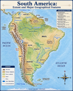
SOUTH AMERICA
Introduction, Location and Extent
- South America is the fourth-largest continent in the world.
- It spans nearly 8 million square kilometres, covering about 12% of Earth’s land area.
- The continent is located predominantly in the Southern Hemisphere.
- It comprises 12 sovereign nations.
- Brazil is the largest country in terms of both area and population.
- South America is connected to North America through the Isthmus of Panama.
- It is bounded by the Pacific Ocean to the west and the Atlantic Ocean to the east.
South America is home to iconic geographical features: the Andes Mountains, Amazon River, Amazon Rainforest, Atacama Desert, and Patagonian Plateau. Its vast natural resources – minerals, freshwater, forests, and fertile land – make it globally strategic, especially for climate regulation, biodiversity, food security, and critical minerals like lithium and copper.
Created by ForumIAS
| Feature | Details |
| Area | 17.8 million sq. km |
| Largest Country | Brazil |
| Highest Peak | Aconcagua (6,961 m) |
| Largest River | Amazon |
| Largest Rainforest | Amazon Rainforest |
| Largest Navigable Lake | Lake Titicaca |
Physical Geography
Andes Mountain System
- The Andes Mountains stretch nearly 7,000 km along the western edge of South America.
- They are the world’s longest continental mountain range.
- The Andes were formed by the subduction of the Nazca Plate beneath the South American Plate.
- They form part of the Pacific Ring of Fire.
- The mountain system contains active volcanoes.
- It also includes high plateaus such as the Altiplano.
- Aconcagua (6,961 m) in Argentina is the highest peak outside Asia.
- The Andes are rich in mineral resources, including:
- Copper
- Silver
- Tin
- Gold
- Lithium
Central Lowlands and River Basins
- Between the Andes Mountains and the eastern highlands lie the vast Central Lowlands.
- The Central Lowlands are drained by three major river systems:
- Amazon Basin
- Orinoco Basin
- La Plata Basin
- Together, these three river basins cover more than half of South America.
Amazon Basin
- The Amazon Basin is the world’s largest river basin.
- It covers approximately 7 million sq. km.
- It contains the largest tropical rainforest on Earth.
- The Amazon River originates in the Peruvian Andes.
- It discharges more water into the ocean than any other river.
- The basin significantly influences the global climate.
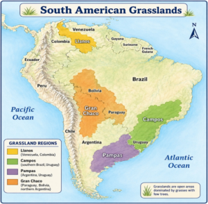
Orinoco Basin
- The Orinoco Basin extends across Venezuela and Colombia.
- It features the Llanos, vast tropical grasslands.
- The Llanos experience seasonal flooding.
- These grasslands support cattle ranching.
- The Orinoco corridor is linked to Venezuela’s petroleum wealth.
La Plata Basin
- The La Plata Basin drains southeastern South America.
- It is drained by the:
- Paraná River
- Paraguay River
- Uruguay River
- It is one of the continent’s most productive economic zones.
- The basin is home to major cities.
- It contains the Itaipu Dam, one of the world’s largest hydroelectric projects.
Created by ForumIAS
Amazon Rainforest
- The Amazon Rainforest covers nearly 5.5 million sq. km.
- It contains approximately 10% of the world’s known biodiversity.
- The rainforest stores immense quantities of carbon.
- It helps regulate climate through evapotranspiration.
- It feeds rainfall across South America and beyond.
- Due to its role in climate regulation, it is often called the “Earth’s Climate Engine.”
Threats to the Amazon Rainforest
- Deforestation
- Illegal logging
- Mining
- Expansion of cattle ranching
- Infrastructure development
- Climate change
Conservation Efforts
- International conservation efforts have achieved some progress in reducing deforestation.
- Despite these efforts, significant challenges remain.
Climate
South America’s diverse climate is shaped by its vast latitudinal range, varied topography, ocean currents (notably the cold Humboldt Current and warm Brazil Current), and the Andes acting as a climatic barrier.
| Climate Type | Major Region |
| Equatorial | Amazon Basin |
| Tropical Savanna | Llanos and Central Brazil |
| Semi-Arid | Northeast Brazil |
| Desert | Atacama Desert |
| Mediterranean | Central Chile |
| Temperate | Pampas |
| Highland | Andes Mountains |
The Atacama Desert of northern Chile is one of the driest places on Earth, shaped by the Humboldt Current, subtropical high pressure, and the Andean rain-shadow effect. In contrast, the Amazon Basin receives over 2,000 mm of rainfall annually, sustaining dense evergreen forests.
Mineral Resources and Economy
- South America is one of the world’s most resource-rich continents.
- Its geology has been shaped by:
- Andean uplift
- Ancient shield areas
- These geological processes have concentrated vast mineral deposits.
| Mineral | Major Producers | Key Use |
| Copper | Chile, Peru | Electrical equipment, EVs |
| Lithium | Chile, Argentina, Bolivia | EV batteries, energy storage |
| Iron Ore | Brazil | Steel industry |
| Gold | Peru, Brazil, Colombia | Jewellery and investment |
| Silver | Peru, Bolivia | Electronics and industry |
Lithium Triangle
- The Lithium Triangle consists of:
- Argentina
- Bolivia
- Chile
- It holds over half of the world’s known lithium reserves.
- The region is central to the global transition towards:
- Electric vehicles (EVs)
- Renewable energy
Petroleum Resources
- Venezuela possesses some of the world’s largest petroleum reserves.
- Brazil’s offshore Pre-Salt Basin is a major source of oil production.
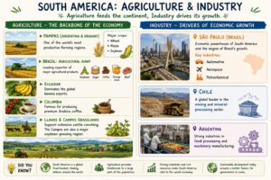
Agriculture
- Agriculture is central to South America’s economy.
- The Pampas of Argentina and Uruguay are among the world’s most productive farming regions.
- Major crops grown in the Pampas include:
- Wheat
- Maize
- Soybean
- Brazil is a global leader in the export of:
- Soybean
- Sugar
- Coffee
- Orange juice
- Beef
- Ecuador is a leading exporter of bananas.
- Colombia is known for producing premium Arabica coffee.
- The Llanos and Campos support extensive cattle ranching.
- The Campos are also a major soybean-producing belt.
Industry
- São Paulo serves as South America’s economic powerhouse.
- It drives Brazil’s:
- Automotive sector
- Aerospace sector
- Petrochemical sector
- Chile leads in:
- Mining
- Mineral processing
- Argentina focuses on:
- Food processing
- Machinery production
Created by ForumIAS
Strategic Significance of South America
- Combination of ecological wealth, mineral resources, agricultural productivity, and freshwater reserves makes South America uniquely important in the 21st century.
- Growing global demand for lithium, copper, and sustainable food is increasing the continent’s geopolitical significance.
- Growing global demand for lithium, copper, and sustainable food is increasing the continent’s economic significance.
- Protection of the Amazon Rainforest remains a major challenge in international environmental diplomacy.
- Conservation of other ecosystems is also one of the most pressing concerns in global environmental governance.
Prelims Questions
Q.1) Which one of the following statements is not true regarding the Atacama ?
(a) It is a desert in South America.
(b) It is World’s driest desert.
(c) It lies in Southern Chile.
(d) It has rich reserves of nitrates.
U.P.P.C.S. (Mains) 2006
Q.2) The wide treeless grassy plain in South America are called
(a) Selvas
(b) Pampas
(c) Prairies
(d) Steppes
U.P.P.C.S. (Pre) 2005
Q.3) Given below are two statements, one is labelled as Assertion (A) and other as Reason (R).
Assertion (A) : The Pampas plain is the main region for cultivation in Argentina.
Reason (R) : The fertile soil of Pampas and the temperate climate are very useful for growing crops and grasses.
Choose the correct answer from the code given below.
Code :
(a) Both (A) and (R) are true and (R) is the correct explanation of (A)
(b) Both (A) and (R) are true but (R) is not the correct explanation of (A)
(c) (A) is true but (R) is false
(d) (A) is false but (R) is true
U.P. R.O./A.R.O. (Mains) 2016
Q.4) Which one of the following is a land locked country?
(a) Surinam
(b) Bolivia
(c) Uruguay
(d) Peru
U.P.P.C.S. (Pre) 2022
Q.5) Which of the following is known as ‘the Continent of Birds’?
(a) Europe
(b) Australia
(c) South America
(d) Asia
U.P.P.C.S. (Pre) 1994
Q.6) With reference to the ‘Galapagos Islands’ situated in the Pacific Ocean, which of the following statements
is/are correct?
(1) They are formed due to volcanic activity.
(2) They are part of South American nation Peru.
Select the correct answer using the code given below:
Code :
(a) Only 1
(b) Only 2
(c) Both 1 and 2
(d) Neither 1 nor 2
U.P. R.O./A.R.O. (Mains) 2021
Expected Mains Questions
Q.1) Why is the Amazon Rainforest often referred to as the “Earth’s Climate Engine”? Explain.
Q.2) Examine the role of the Humboldt Current in shaping the climate of western South America.
Q.3) Explain the role of the Pampas in South America’s agricultural development.