Study Approach
Start with the big picture
Do not begin by memorizing ranges, peaks, or passes. First understand the Himalayas as a tectonic mountain system formed by plate collision. Then follow the chapter’s natural flow:
Formation → Characteristics → Latitudinal Divisions → Longitudinal Divisions → Significance
This sequence helps you connect physical geography with climate, rivers, economy, biodiversity and strategic importance.
Major Study Blocks
Block 1: Formation and Evolution of the Himalayas
Focus on understanding rather than memorizing.
Study:
- Gondwanaland
- Tethys Sea
- Indian Plate movement
- Collision with Eurasian Plate
- Folding and upliftment
- Ongoing tectonic activity
What to understand:
- Why Himalayas are called young fold mountains.
- Why earthquakes are frequent.
- Why rivers have deep gorges and V-shaped valleys.
What to memorize:
- Tethys Sea
- Indian Plate–Eurasian Plate collision
- Approximate northward movement of the Indian Plate.
Block 2: General Characteristics
Treat this as a fact-based Prelims section.
Memorize:
- Length and width
- Syntaxial bends
- Third Pole concept
- Important glaciers
- Highest peaks
Prepare a one-page table:
| Feature | Example |
| Glacier | Gangotri, Siachen |
| Peak | Everest, K2 |
| Syntaxial Bend | Nanga Parbat, Namcha Barwa |
Block 3: Latitudinal Divisions
This is the most important classification.
Focus on:
- Relative location
- Elevation
- Rock composition
- Major ranges
- Important valleys and passes
This section is highly relevant for both Prelims and Mains.
Block 4: Longitudinal Divisions
Study the Himalayas from west to east.
Practice remembering:
- Indus–Satluj
- Satluj–Kali
- Kali–Tista
- Tista–Dihang
- Purvanchal Extension
Use a flowchart rather than paragraphs.
Active recall method:
Draw India and label all five divisions from memory.
Block 5: Significance of the Himalayas
This is the most important Mains section.
Study under dimensions:
- Climatic
- Water resources
- Economic
- Strategic
- Environmental
Understand interconnections:
- Himalayas → Rivers → Agriculture
- Himalayas → Monsoon → Climate
- Himalayas → Biodiversity → Ecology
- Himalayas → Borders → Security
Diagram-Based Preparation
Practice repeatedly:
- Plate tectonic collision diagram
- Latitudinal cross-section of Himalayas
- Longitudinal division map
- West-to-east Himalayan divisions
- Purvanchal extension map
A simple labelled sketch can significantly improve Geography answers.
Important for Prelims
- Formation process
- Major ranges
- Peaks and glaciers
- Mountain passes
- Syntaxial bends
- Bhabar and Dun regions
- Longitudinal divisions
Important for Mains
- Himalayas and Indian climate
- Himalayas as Water Tower of Asia
- Biodiversity significance
- Strategic importance
- Environmental challenges
- Role in disaster management and sustainable development
Physiographic Units of India: The Himalayas
| Table Content |
| Formation of the Himalayas |
| Important Characteristics |
| Latitudinal Division of the Himalayas |
| Longitudinal Division of the Himalayas |
| Significance of the Himalayas |
The Himalayas are the most prominent physiographic feature of India and constitute the world’s highest, youngest, and most extensive fold mountain system. They were formed as a result of the collision between the Indian Plate and the Eurasian Plate. Covering about 10.7% of India’s geographical area, the Himalayan mountain chain extends approximately 2,400 km from the Indus Gorge in the west to the Brahmaputra Gorge in the east. Its width varies from nearly 400 km in Kashmir to about 150 km in Arunachal Pradesh. The region is characterized by lofty peaks, deep valleys, glaciers, gorges, waterfalls, and snow-covered mountains.
Formation of the Himalayas
Around 225 million years ago, the Indian landmass existed as part of Gondwanaland and was separated from Asia by the Tethys Sea. During the breakup of Gondwanaland, the Indian Plate drifted northward and eventually collided with the Eurasian Plate. The sediments deposited in the Tethys Sea were compressed, folded, and uplifted, leading to the formation of the Himalayan Mountain System.
This mountain-building process occurred in several phases, resulting in the development of multiple parallel ranges. The Himalayas continue to rise even today because the Indian Plate is still moving northward by a few centimetres every year. Frequent earthquakes, deep river valleys, and modern GPS measurements provide evidence of this ongoing tectonic activity.
Important Characteristics
The Himalayas possess several unique geographical features:
- They form a giant arc convex towards the south.
- The region contains some of the world’s highest peaks, including Mount Everest (8,848.86 m).
- Numerous glaciers such as Gangotri, Yamunotri, Siachen, Milam, and Zemu originate here.
- Rivers have carved deep V-shaped valleys and spectacular gorges.
- The mountain chain exhibits Syntaxial Bends near Nanga Parbat in the west and Namcha Barwa in the east.
- Due to their vast reserves of snow and ice, the Himalayas are often called the “Third Pole of the Earth.”
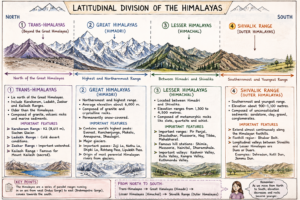
Latitudinal Division of the Himalayas
- Trans-Himalayas
The Trans-Himalayas lie north of the Great Himalayas and include the Karakoram, Ladakh, Zaskar, and Kailash Ranges. These ranges are older than the Himalayas and consist mainly of granite, volcanic rocks, and marine sediments.
The Karakoram Range contains K2 (8,611 m), the world’s second-highest peak, and the Siachen Glacier, one of the largest glaciers outside the polar regions. The Ladakh Range is characterized by cold desert conditions, while the Zaskar Range forms an important watershed. The Kailash Range is famous for Mount Kailash, a sacred mountain for several religions.
- Great Himalayas (Himadri)
The Himadri is the northernmost and highest Himalayan range, with an average elevation of about 6,000 metres. It consists largely of granite and crystalline rocks and remains permanently snow-covered.
Most of the world’s highest peaks, including Everest, Kanchenjunga, Makalu, Annapurna, and Dhaulagiri, are situated in this range. The Himadri contains major glaciers and important mountain passes such as Zoji La, Nathu La, Shipki La, Rohtang Pass, and Lipulekh Pass. Most perennial Himalayan rivers originate from glaciers located in this region.
- Lesser Himalayas (Himachal)
Located between the Himadri and the Shivaliks, the Lesser Himalayas have elevations ranging from 1,300 to 4,500 metres. They are mainly composed of metamorphic rocks such as slate, quartzite, and schist.
Important ranges include the Pir Panjal, Dhauladhar, Mussoorie, Nag Tibba, and Mahabharat Ranges. The region contains famous hill stations like Shimla, Mussoorie, Nainital, and Dharamshala. Important valleys such as the Kashmir Valley, Kullu Valley, Kangra Valley, and Kathmandu Valley are also found here.
- Shivalik Range (Outer Himalayas)
The Shivaliks form the southernmost and youngest Himalayan range. They extend almost continuously along the Himalayan foothills with an elevation of about 900–1,100 metres. These ranges are mainly composed of unconsolidated sediments such as sandstone, clay, gravel, and conglomerates.
The foothill region consists of the Bhabar Belt, while longitudinal valleys between the Shivaliks and Lesser Himalayas are known as Duns or Duars. Examples include Dehradun, Kotli Dun, and Jammu Dun.
Created by ForumIAS
Longitudinal Division of the Himalayas
Kashmir or Punjab Himalayas
Stretching between the Indus and Satluj Rivers, this region contains the Karakoram, Ladakh, Zaskar, Pir Panjal, and Dhauladhar Ranges. It is famous for the Kashmir Valley, Karewa Deposits, and glaciers such as Siachen and Baltoro. High-altitude lakes like Pangong Tso and Tso Moriri are also located here.
Kumaon Himalayas
Situated between the Satluj and Kali Rivers, this region includes the Garhwal and Kumaon Himalayas. Prominent peaks include Nanda Devi, Kamet, Trisul, and Chaukhamba. Major pilgrimage centres such as Badrinath, Kedarnath, Gangotri, and Yamunotri are located here.
Nepal Himalayas
Extending between the Kali and Tista Rivers, the Nepal Himalayas represent the highest section of the Himalayan system. Mount Everest, Kanchenjunga, Lhotse, Makalu, and Annapurna are located in this region. The famous Kathmandu Valley and Pokhara Valley also occur here.
Assam Himalayas
Located between the Tista and Dihang Rivers, the Assam Himalayas receive heavy monsoonal rainfall and experience intense river erosion. Important passes include Nathu La and Jelep La. The region forms part of the Eastern Himalayan Biodiversity Hotspot.
Purvanchal Hills
After the Himalayan chain takes a sharp southward turn near the Dihang Gorge, it continues as the Purvanchal Hills. These include the Patkai Bum, Naga Hills, Manipur Hills, Barail Hills, Garo Hills, Khasi Hills, Jaintia Hills, and Mizo Hills.
The region is characterized by dense forests, heavy rainfall, rich biodiversity, and shifting cultivation (Jhum). The mountain system further extends into Myanmar as the Arakan Yoma and continues towards the Andaman and Nicobar Islands.
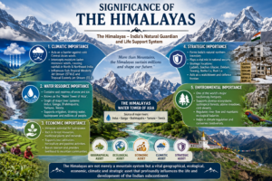
Significance of the Himalayas
Climatic Importance
The Himalayas act as a barrier against cold Central Asian winds and intercept moisture-laden monsoon winds, causing rainfall over northern and northeastern India. They also influence important atmospheric systems such as the Sub-Tropical Westerly Jet Stream (STWJ) and the Tropical Easterly Jet Stream (TEJ).
Water Resource Importance
The Himalayas are known as the “Water Tower of Asia” because they contain enormous reserves of snow and ice. Major river systems such as the Indus, Ganga, Brahmaputra, Yamuna, and Teesta originate here and support millions of people.
Economic Importance
The region provides immense hydroelectric potential, valuable forest resources, medicinal plants, and minerals. Tea cultivation, horticulture, and pastoral activities are important economic activities in the Himalayan region.
Strategic Importance
The Himalayas form India’s natural northern boundary and play an important role in national security. Strategic locations such as Ladakh, Siachen Glacier, Doklam, Tawang, Nathu La, and Bum La are situated in this region.
Environmental Importance
The Himalayas constitute one of the world’s major biodiversity hotspots and support diverse ecosystems ranging from subtropical forests to alpine meadows and cold deserts. They regulate river flow, conserve biodiversity, and contribute significantly to climate regulation and ecological balance.
Created by ForumIAS
Thus, the Himalayas are the lifeline of the Indian subcontinent, acting as a climatic regulator, water reservoir, biodiversity hotspot, economic resource base, and strategic frontier, making them indispensable for India’s sustainable development and security.
Prelims Questions
Q.1) Which of the following mountain ranges are in the Himalayan mountains?
- Cho Oyu
- Lhotse
- Annamalai
- Sirumali
Select the correct answer from the code given below:
Code:
(a) Only 1, 2 and 3
(b) Only 1 and 2
(c) Only 2, 3 and 4
(d) Only 3 and 4
U.P.P.C.S. (Pre) 2022
Q.2) Which of the following rivers of India cuts across all the ranges of the Himalayas?
(a) Ravi
(b) Satluj
(c) Beas
(d) Chenab
U.P.R.O./A.R.O (Mains) 2014/U.P.P.C.S. (Mains) 2012
Q.3) Which of the following is an important tribe of Dhauladhar Range?
(a) Abor
(b) Gaddi
(c) Lepcha
(d) Tharu
U.P. Lower Sub. (Pre) 2003 U.P.U.D.A./L.D.A. (Pre) 2002 U.P.P.C.S. (Pre) 2001
Q.4) Meghalaya plateau is the part of
(a) Himalayan Range
(b) Peninsular Plateau
(c) Mountains of Eastern Ghats
(d) Satpura Range
U.P.U.D.A./L.D.A. (Pre) 2013
Q.5) The Kullu Valley is situated between the mountain ranges of:
(a) Dhauladhar and Pir Panjal
(b) Ranjoti and Nagtibba
(c) Ladakh and Pir Panjal
(d) Middle Himalayas and Shiwalik
U.P. Lower Sub. (Spl.) (Pre) 2002/U.P.P.C.S. (Pre) 1999
Q.6) With reference to the ‘Trishul Peak in Himalayas’, which of the following statements is/are correct?
(1) It is situated in Bageshwar district of Uttarakhand.
(2) The peak is more than 7500 m high.
Select the correct answer from the code given below.
Code:
(a) Only 1
(b) Only 2
(c) Both 1 and 2
(d) Neither 2 nor 2
U.P. R.O./A.R.O. (Mains) 2021
Q.7) Which one of the following gives correct sequence of Himalayan peaks in the direction east to west?
(a) Dhaulagiri, Kanchenjunga, Makalu, Mount Everest
(b) Namcha Barwa, Kanchenjunga, Nanda Devi, Mount Everest
(c) Makalu, Dhaulagiri, Kumaun, Namcha Barwa
(d) Namcha Barwa, Kanchenjunga, Mount Everest, Nanda Devi
U.P.P.C.S. (Spl) (Mains) 2008
Expected Mains Questions
Q.1) Discuss the latitudinal divisions of the Himalayas and highlight the distinctive characteristics of each.
Q.2) Examine the role of Himalayan glaciers in sustaining India’s river systems.
Q.3) Explain the strategic significance of the Himalayan region for India’s national security.