
This article provides a comprehensive overview of India’s drainage system, beginning with the concept of drainage, drainage basins, and river classification. It explains the major drainage patterns and essential river-related terminologies before discussing the drainage systems of India based on orientation and origin. The article further examines the Himalayan drainage system, including the Indus, Ganga, and Brahmaputra river systems, their origins, tributaries, courses, and significance, along with contemporary issues related to river conservation and sustainable water management.
Study Approach
Start with the big picture: Begin by understanding that follows a logical sequence: Drainage System → Drainage Patterns → Drainage Terminologies → Classification of Indian Drainage → Himalayan River Systems (Indus, Ganga, Brahmaputra). Instead of memorizing rivers individually, first understand how rivers develop, why they follow different courses, and how geological factors shape drainage networks.
Study Block 1: Basics of Drainage
Start with the fundamental concepts—drainage, drainage basin, watershed, tributary, distributary, delta, and estuary.
How to Read This Block
- Understand the meaning of each term instead of rote learning.
- Learn the relationship among catchment area → basin → watershed.
- Memorize the classification of rivers based on catchment size.
Study Block 2: Drainage Patterns
How to Read This Block
First understand the difference between:
- Discordant vs Concordant drainage
- Antecedent vs Superimposed
- Consequent vs Subsequent
Study Block 3: Indian Drainage Classification
Study the drainage systems according to:
- Bay of Bengal
- Arabian Sea
- Inland drainage
Study Block 4: Himalayan River Systems
Study each river using one fixed framework:
- Origin
- Course
- Major tributaries
- States crossed
- Important projects/dams
- Special geographical features
- Mouth
Apply this framework separately for:
- Indus
- Ganga
- Brahmaputra
Do not mix tributaries. Prepare separate left-bank and right-bank lists.
Important for Prelims
- Origins and mouths of rivers
- Tributaries
- River-bank classifications
- Drainage patterns and examples
- Important lakes, dams, glaciers, and passes
- Inland drainage examples
- National Waterways
Important for Mains
- Evolution of the Himalayan drainage system
- Geological controls on river courses
- Significance of major river systems
- River basin management
- Floods, sediment transport, and ecological conservation
- Interlinking of rivers and sustainable water resource management
Drainage System
| Table Content |
| Drainage Patterns |
| The Drainage System of India |
| The Indus River System |
| The Ganga River System |
| The Brahmaputra River System |
Drainage refers to the flow of water through well-defined natural channels such as rivers, streams, and tributaries, which together form an interconnected Drainage System. This system collects water from sources like rainfall, snowmelt, and glaciers, carrying it toward an outlet such as a sea, ocean, or inland basin. The development of these networks depends on geological structures, rock types, slopes, relief, climate, and regional tectonic history.
Based on the size of their catchment areas (drainage basins), rivers are classified as follows:
- Large Rivers: Catchment area above 20,000 sq. km.
- Medium Rivers: Catchment area between 2,000 and 20,000 sq. km.
- Small Rivers: Catchment area below 2,000 sq. km.
Drainage Patterns
A drainage pattern refers to the geometric arrangement of a river and its tributaries across a landscape, primarily controlled by regional topography and geology. These are broadly divided into Discordant and Concordant systems:
- Discordant Drainage Patterns
In this pattern, rivers maintain their original courses irrespective of subsequent changes in the topography or geological structure, making them older than the landforms through which they flow.
- Antecedent Drainage: These rivers existed before the upliftment of the land. As tectonic forces raised the landscape, the rivers cut downward to form deep gorges. Examples include the Indus, Sutlej and Brahmaputra.
- Superimposed (Superinduced) Drainage: These rivers develop their courses on a younger surface layer and eventually erode through to cut into underlying, older rock structures without adjusting to them. Examples include the Damodar and Chambal.
- Concordant Drainage Patterns
The courses of these rivers are highly controlled by the regional slope, relief and underlying rock structures. This is the most common category observed in India.
- Consequent Rivers: These flow directly in the direction of the original land slope and are the first to develop on a new surface. Examples include the major eastward-flowing Peninsular rivers like the Godavari, Krishna, Cauvery and Mahanadi.
- Subsequent Rivers: These develop later along zones of structural weakness or softer rocks, typically joining the main consequent rivers at right angles. Examples include the Chambal, Betwa and Son.
Primary Geometric Drainage Typologies
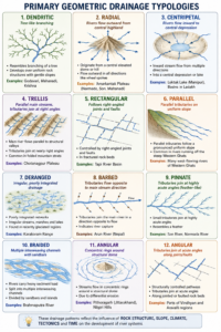
Created by ForumIAS
Basic Drainage Terminologies
- Catchment Area: The exact geographical area from which a river gathers its water.
- Drainage Basin / River Basin: The entire landscape drained by a river system and all its tributaries.
- Watershed: The elevated land boundary or divide separating one drainage basin from another. Large units are called basins; smaller units are called watersheds.
- Tributary: A smaller stream joining a larger river, boosting its volume.
- Distributary: A branching channel that leaves the main river (typically in a delta) to carry water away from the parent stream.
- Mouth: The terminal point where a river empties into a larger body of water.
- Delta: A depositional landform built at a river’s mouth out of accumulated alluvial sediments.
- Estuary: A funnel-shaped river mouth where freshwater meets surging seawater due to a submerged valley.
The Drainage System of India
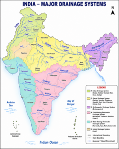
Created by ForumIAS
India’s drainage network is categorized by orientation and by geographical origin:
- Categorization by Orientation
- Bay of Bengal Drainage: Covers nearly 77% of India’s drainage area. It includes eastward-flowing rivers like the Ganga, Brahmaputra, Mahanadi, Godavari, Krishna, and Cauvery.
- Arabian Sea Drainage: Covers about 23% of India’s drainage area. It includes westward-flowing rivers like the Indus, Narmada, Tapi, Mahi, and Sabarmati.
- Inland Drainage: Endorheic basins where rivers terminate inside continental lakes or marshes without reaching the sea. Examples include the Luni River (terminating in the Rann of Kutch) and streams feeding Sambhar Lake in Rajasthan.
- The Himalayan Drainage System
The Himalayan Drainage System evolved alongside the upliftment of the Himalayan fold mountains during the collision of the Indian and Eurasian plates. Geologists theorize that a single massive ancient river—the Indo-Brahma (Shiwalik) River—once flowed from Assam to Sindh before Pleistocene tectonic movements and the upliftment of the Potwar Plateau fractured it into the Indus, Ganga, and Brahmaputra systems. Concurrently, the formation of the Malda Gap directed the Ganga and Brahmaputra toward the Bay of Bengal.
The Indus River System
The Indus River (Sindhu) spans 3,180 km globally, with 1,114 km flowing through India. It originates near Lake Manasarovar (Kailash Range) in Tibet, where it is called the Senge Tsangpo (“Lion River”). It flows northwest through Ladakh, enters Gilgit-Baltistan, and runs south across Pakistan to exit into the Arabian Sea. It holds ecological significance as the habitat of the endangered Indus River Dolphin.
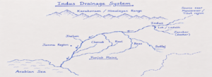
Created by ForumIAS
Major Tributaries
- Right Bank: Shyok, Gilgit, Hunza, Shigar, Nubra, Kabul, Kurram, Gomal.
- Left Bank: Zanskar, Jhelum, Chenab, Ravi, Beas, Sutlej.
Key Left-Bank Rivers
- Jhelum: Originates at Verinag Spring (Pir Panjal Range), flows through Srinagar into Wular Lake, and cuts a deep canyon before joining the Chenab. Its main tributary is the Kishanganga.
- Chenab: The largest Indus tributary by volume. Formed by the confluence of the Chandra and Bhaga rivers at Tandi (Himachal Pradesh), it hosts the Baglihar Dam and the ultra-high Chenab Rail Bridge.
- Ravi: Rises in the Dhauladhar Range near Rohtang, flows through the Chamba Valley, and feeds the Ranjit Sagar Dam.
- Beas: Originates at Beas Kund near Rohtang Pass, flows through the Kullu Valley, and terminates entirely within India by joining the Sutlej at Harike.
- Sutlej: Originates from Rakshas Tal (Tibet) as the Langqen Zangbo, enters India via Shipki La Pass, and hosts the massive multi-purpose Bhakra-Nangal Project.
The Ganga River System
The largest river system in India, the Ganga supports the dense population of the Indo-Gangetic Plain.
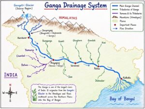
Created by ForumIAS
Origin and the Panch Prayag
The river officially originates in the Garhwal Himalayas of Uttarakhand, where its primary source stream, the Bhagirathi (emerging from the Gangotri Glacier at Gomukh), unites with the Alaknanda (from the Satopanth Glacier near Badrinath) at Devprayag. The Alaknanda meets other mountain streams along its course, forming the five sacred confluences known as the Panch Prayag:
- Vishnuprayag: Alaknanda + Dhauliganga.
- Nandaprayag: Alaknanda + Nandakini.
- Karnaprayag: Alaknanda + Pindar.
- Rudraprayag: Alaknanda + Mandakini.
- Devprayag: Alaknanda + Bhagirathi (forming the official Ganga).
Course and Lower Flow
The Ganga enters the plains at Haridwar and travels 2,525 km across five states. At Prayagraj, it meets its largest tributary, the Yamuna, at the Triveni Sangam. At Farakka (West Bengal), it bifurcates into the Bhagirathi-Hooghly (flowing through West Bengal) and the Padma (entering Bangladesh). The Padma joins the Brahmaputra (Jamuna) and Meghna systems to form the Sundarbans Delta before draining into the Bay of Bengal.
Major Tributaries
- Left Bank: Ramganga, Gomti, Ghaghara, Gandak, Kosi, Mahananda.
- Right Bank: Yamuna, Son, Damodar.
Key Tributaries of the Ganga
- Yamuna: Longest tributary, originating at Yamunotri Glacier (Bandarpunch Peak). It flows parallel to the Ganga for 1,376 km before joining at Prayagraj. Its left-bank tributaries include the Hindon, while right-bank tributaries are the Chambal, Sind, Betwa, and Ken.
- Chambal: Rises in the Janapav Hills (Vindhyan Range, MP) and flows through Rajasthan and UP. Famous for its badland topography (Chambal Ravines), it hosts the National Chambal Sanctuary for Gharials and supports the Gandhi Sagar, Rana Pratap Sagar, and Jawahar Sagar dams.
- Betwa (Vetravati): Rises in the Vindhyan Hills near Bhopal, providing crucial irrigation water to the drought-prone Bundelkhand region before joining the Yamuna near Hamirpur.
- Ken: Rises in MP and cuts across the Panna Tiger Reserve, sustaining a fragile riparian ecosystem rich in wildlife before merging with the Yamuna.
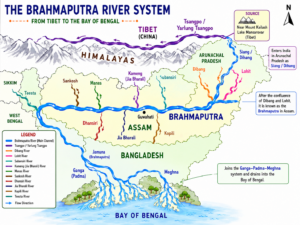
The Brahmaputra River System
The Brahmaputra originates at the Chemayungdung Glacier near Lake Mansarovar in Tibet, where it flows east parallel to the Himalayas as the Yarlung Tsangpo (“the purifier”).
Created by ForumIAS
The Great Bend and Indian Course
Near Namcha Barwa, it takes a sharp U-turn (Great Bend) to cut a deep gorge into Arunachal Pradesh, where it is called the Siang or Dihang. After joining the Lohit and Dibang rivers, it becomes the Brahmaputra and enters the Assam Valley as a massive braided river. It flows west and turns south into Bangladesh near Dhubri, taking the name Jamuna before combining with the Padma and Meghna. It serves as National Waterway-2 (Sadiya to Dhubri).
Major Tributaries
- Lohit: Carries red lateritic soils, giving the lower river a reddish hue.
- Subansiri: The largest, antecedent tributary of the Brahmaputra; site of the Subansiri Lower Hydroelectric Project.
- Dibang: Mountainous river flowing through the Mishmi Hills.
- Kameng: Flows directly between two premier ecological reserves: Eaglenest Wildlife Sanctuary and Pakke Tiger Reserve.
- Manas: A vital transboundary river supporting the contiguous Royal Manas National Park (Bhutan) and Manas National Park (India).
- Teesta: The “lifeline of Sikkim”, originating near Kanchenjunga. It receives the Rangeet River, carves through the Darjeeling hills, and flows into Bangladesh to join the Jamuna.
The Himalayan glaciers are the foundation of India’s river systems and water security. Their rapid retreat due to climate change threatens river flows, agriculture, hydropower generation, biodiversity, and human livelihoods. At the same time, growing water scarcity highlights the urgent need for sustainable water management. A combination of climate mitigation, glacier conservation, water-use efficiency, and scientific river basin planning will be essential to safeguard India’s future water resources.
Prelims Questions
Q.1) Which of the following rivers have almost the same point of the beginning?
a) Brahmaputra and Ganga
b) Tapi and Beas
c) Brahmaputra and Indus
d) Indus and Ganga
U.P.P.C.S. (Pre) 2006
Q.2) Given below are two statements, one is labelled as Assertion (A) and other as Reason (R):
Assertion (A): Teesta river was earlier a tributary of Ganga now it is a tributary of Brahmaputra.
Reason (R): River capturing is a major feature of Himalayan rivers.
Select the correct answer using the codes given below.
Codes:
a) Both (A) and (R) are true and (R) is correct explanation of (A).
b) Both (A) and (R) are true, but (R) is not correct explanation of (A).
c) (A) is true, but (R) is false.
d) (A) is false, but (R) is true.
U.P.P.C.S. (Pre) 2021
Q.3) Which one of the following rivers originates at Amarkantak?
a) Damodar
b) Mahanadi
c) Narmada
d) Tapti
U.P.P.C.S. (Mains) 2008
Q.4) Which of the following is the actual source of Son river?
a) Amarkantak in Shahdol district
b) Sonmuda in Shahdol district
c) Son Bacharwar in Bilaspur district
d) Mandla Plateau
U.P.P.C.S. (Mains) 2007
Q.5) Which one of the following rivers is called the Ganga of the South?
a) Cauvery
b) Krishna
c) Godavari
d) Narmada
U.P.P.C.S. (Pre) 2015
Q.6) Which of the following rivers has the largest catchment area?
a) Narmada
b) Cauvery
c) Godavari
d) Krishna
U.P.P.C.S. (Pre) 2009
Q.7) The Hagari river is a tributary of:
- a) Bhima
- b) Godavari
- c) Krishna
- d) Tungabhadra
U.P.P.C.S. (Mains) 2009
Expected Mains Questions
Q.1) Explain the evolution of the Himalayan drainage system. Discuss the geological factors responsible for the present drainage pattern of northern India.
Q.2) Discuss the physiographic and climatic factors responsible for the formation of the Ganga River system.
Q.3) Evaluate the ecological and economic significance of the Indus River system for India despite a major part of the basin lying outside its territory.
Q.4) Critically examine the causes of recurrent floods in the Ganga-Brahmaputra basin. Suggest suitable measures for sustainable river basin management.