ForumIAS announcing GS Foundation Program for UPSC CSE 2025-26 from 19 April. Click Here for more information.
Contents
- 1 Introduction
- 2 What are the existing Flood Management Mechanisms in India?
- 3 What are the reasons behind the frequent floods in Assam?
- 4 What are the adverse impacts of floods?
- 5 What are some positive impacts of Floods?
- 6 What steps have been taken by the Government for flood management?
- 7 What are the flaws in the flood management in India?
- 8 What are the recommendations of the Parliamentary Standing Committee on Water Resources?
- 9 Conclusion
| For 7PM Editorial Archives click HERE → |
Introduction
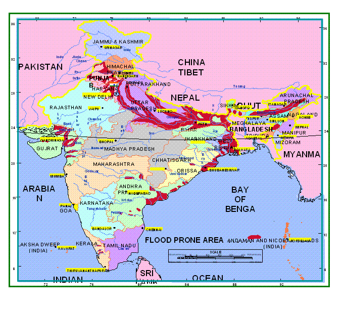
Flood is an overflow of a large amount of water beyond its normal limits, especially over what is normally dry land. Recently, over 5.5 million people have been affected in 32 districts of Assam (out of 35) due to the devastating floods as per the Assam Disaster Management Authority. Occurrence of devastating floods in Assam is common. The State has witnessed the same on multiple occasions. In the last century, devastating floods occurred in 1934, 1950, 1954, 1955, 1966, 1988 and 2004.
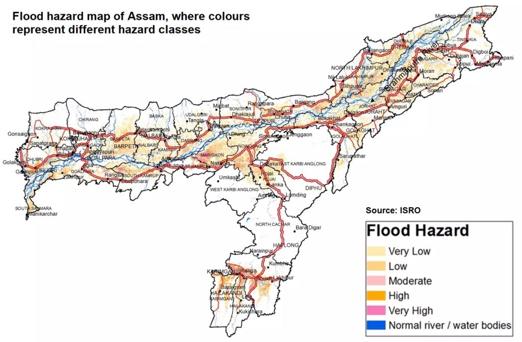
Assam has vast network of rivers. The flood prone area of India stands at about 10.2% of the total area but the flood prone area of Assam is 39.58 % of the area of the state. Hence, Assam has four times the flood prone area than national average. Further, Guwahati’s topography is shaped like a bowl which makes it susceptible to waterlogging. The city has been uniquely shaped by three hills that accumulate water during the monsoon.
Considering this, Assam can strengthen embankments, dredge rivers, address river erosion and take wise policy decisions if it wants to effectively manage floods in the future. These measures were suggested by the Parliamentary Standing Committee on Water Resources in its report released in August last year.
What are the existing Flood Management Mechanisms in India?
In India, there is a two tier system of flood management:
State Level Mechanism : The State Level Mechanism includes the Water Resources Departments, State Technical Advisory Committee and Flood Control Board. In some States, the Irrigation Departments and Public Works Departments look after flood matters.
Union Government Mechanism: The Union Government has set up multiple organizations and various expert committees to enable the State Governments in addressing flood problems in a comprehensive manner.
Central Water Commission (CWC): It was set up for achieving the goal of furthering and promoting measures of flood control. It also focuses on conservation and utilization of water resources throughout the country in the areas of irrigation, hydropower generation, flood management and river conservation.
Brahmaputra Board: The Government of India set up the Brahmaputra Board under the Brahmaputra Board Act, 1980 (46 of 1980) under the then Ministry of Irrigation (now Ministry of Jal Shakti). The jurisdiction of the Board includes all NE States in the Brahmaputra and Barak Basin.
National Disaster Management Authority (NDMA): The aim of the NDMA is to prevent and mitigate disasters including floods. It focuses on undertaking a holistic, coordinated and prompt response to any disaster situation. The Government of India has set up a National Disaster Management Authority (NDMA) in 2005 under the Chairmanship of Hon’ble Prime Minister of India.
What are the reasons behind the frequent floods in Assam?
Natural
Intensified Monsoon: The Bay of Bengal has a major influence on the monsoon in Northeast India. This year there were two coupled ocean-atmosphere phenomena; La Nina in the Pacific Ocean and a Negative Dipole in the tropical Indian Ocean. The two phenomena combined to cause high rainfall in the Bay of Bengal. As a result, weeks before the usual monsoon season, rains had already drenched the basin.
Climate Change: The rise in global temperatures creates a warmer atmosphere. Warmer air can hold more moisture leading to intense bouts of rain and eventually flooding the region. Further, climate change is intensifying the melting of glaciers in the Himalayas that can enhance the magnitude of flooding in the northeast.
Topography: Assam is home to a vast network of rivers, including the Brahmaputra and Barak River. More than 50 tributaries feeding them. Assam also receives river water from neighbouring states like Arunachal Pradesh and Meghalaya. The flat topography and large water flow results in inundation of land.

Volatile Nature of Brahmaputra: Brahmaputra River is braided and unstable in its entire reach in the Assam Valley except for a few places.The instability of the river is attributed to high sediment charge and steep slopes. The river also changes course frequently and it’s virtually impossible to contain it within embankments. The width of the river Brahmaputra has increased up to 15 kilometres at some places due to bank erosion. It is estimated that annually nearly 8,000 hectares land is lost to erosion.
Earthquakes/Landslides: Assam and other parts of the North-eastern region are prone to frequent earthquakes which cause landslides.The landslides and earthquakes send in a lot of debris in the rivers causing the river bed to rise.
Anthropogenic
Dams: One of the key causes of floods in the Assam region is the unregulated release of water from dams situated uphill.
Unplanned expansion of the urban areas: From an estimated 11,000 people in 1901, Guwahati now is home to close to 1.1 million people. Rapid population growth has led to severe encroachments of the wetlands, low lying areas, hills and shrinkage of forest cover. Further a poor drainage system is also a key reason for water-logging in cities that eventually leads to flooding.
What are the adverse impacts of floods?
Loss of Life: The most devastating impact of floods is the loss of precious human lives. In the recent Assam Floods, the death toll has already reached 170.
Habitat Loss: In many parts of the State, both rural and urban, shoals of water drove people from their homes and forced many of them to seek shelter for their livestock. So far, 1.38 lakh houses have been totally or partially damaged.
Deters Food Security: In many places, people failed to save standing crops. Granaries were damaged and mud houses were filled with sand brought by the rivers in spate.
Economic Loss: Numerous critical infrastructure like buildings, power lines, communication lines etc.. get damaged due to flooding. Roads get blocked due to which people are unable to carry out their livelihood. Thus it brutally impacts the economy of a region.
Environmental Degradation: Not only humans but our pristine environment composed of a diverse variety of flora and fauna also faces the brunt of excessive flooding. Numerous animals die and trees get uprooted due to excessive flooding.
What are some positive impacts of Floods?
First, floods generate a bounty of fish and rejuvenate flood-plain ecosystems all along the Brahmaputra, including in the Kaziranga. This landscape has been shaped over millions of years with the help of an active monsoonal environment and mighty rivers that carry sediments weathered from the still-rising Himalaya.
Second, the annual floods are a natural way to enrich the soils, which have a propensity to get depleted.

What steps have been taken by the Government for flood management?
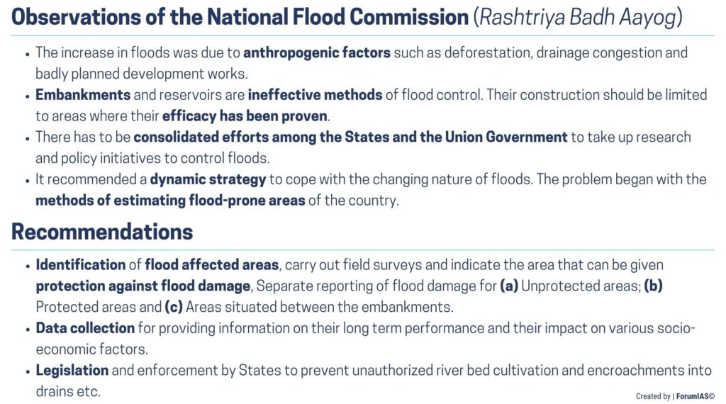
National Flood Commission (Rashtriya Barh Ayog): The Commission submitted its comprehensive report in March 1980. It contained a total of 207 recommendations covering the entire gamut of problems related to floods in the country.
R Rangachari Committee: It was set up by the Ministry of Water Resources, Government of India in October 2001 to review the implementation of recommendations of the National Flood Commission.
National Water Policy (1987/ 2002/2012): The Government of India has laid significant emphasis on the management of floods under the policy.
What are the flaws in the flood management in India?
The biggest shortcoming has been lack of implementation of the recommendations of the National Flood Commission. A report by the CAG in 2017 observed that flood-prone States had not identified or demarcated affected areas in spite of recommendations by multiple committees. Only two of the 17 audited States had verified RBA’s assessment of flood-prone areas. The data were to be used for drawing maps of areas affected by floods. This had also not been implemented.
The National Water Policy of 2012, had specified preparation of digital elevation models and frequency-based Flood inundation maps. These have also not been prepared.
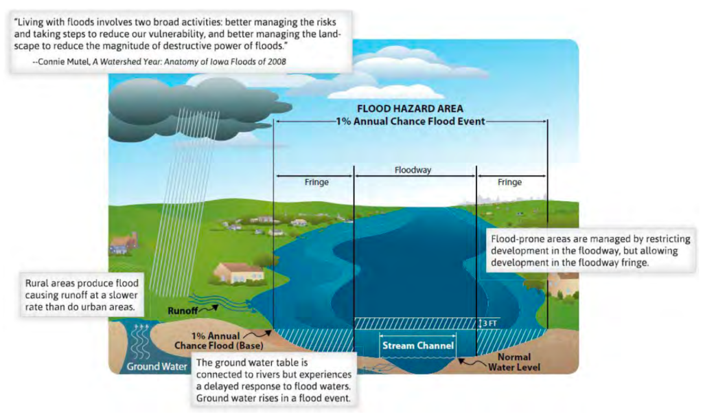
The Central Water Commission (CWC) had circulated a Model Bill for Flood Plain Zoning among States for enactment in 1975. Flood Plain Zoning demarcates zones or areas likely to be affected by floods of different magnitudes or frequencies the damage can be mitigated. The CAG report observed that only 3 States (Manipur, Rajasthan and Uttarakhand) had enacted Flood Plain Zoning Acts.
The CAG Report had observed that the damage to life and property in Uttarakhand (2013) and Chennai (2015) floods would have been much lesser, had the recommendations been implemented.
What are the recommendations of the Parliamentary Standing Committee on Water Resources?
Strengthen embankments along the rivers: Most flood protection structures in Assam are over 50-60 years old. These were constructed on the main stem of the Brahmaputra and its tributaries way back in the 1960s and have become weak now.
Dredging of Rivers: Dredging is the removal of sediments and debris from the bottom of lakes, rivers, harbours, and other water bodies. It is a routine necessity in waterways around the world because sedimentation—the natural process of sand and silt washing downstream—gradually fills channels and harbors.
Improve Alert and Forecasting: There is a need to set up modern weather stations in the upstream catchment of all dams in the North East and install sirens on river banks near dams. This would alert downstream populations in the event of floods.
Inclusion of river erosion in an admissible list of calamities: The Government should consider inclusion of river erosion in the admissible list of calamities for availing assistance under the National Disaster Response Fund/State Disaster Response Fund.
Address Vacancies in the Brahmaputra Board: The Brahmaputra Board which has been functional since 1982 does not have enough manpower. The Report had asked the Board to fill up all vacant posts on a priority basis.
Enact Flood Zoning Bill: Major flood-prone states such as UP, Bihar, West Bengal, Assam, Odisha etc. have not taken the initiative to enact the Flood Plain Zoning Bill. The Law must be enacted to regulate activities in the floodplains. This will help mitigate the damage to life and property.
Source: Philadelphia.gov
Set up River Basin Organizations: The report strongly recommended the setting up of River Basin Organizations or RBOs. These would effectively provide immediate, short-term and long-term solutions in addition to the overall development of the river basin.
Mitigation Measures: Measures such as Afforestation and rejuvenation of wetlands should be taken to mitigate the impact of floods.
Conclusion
Assam and numerous other States in India are going to face increased flooding in future, especially considering the rapid climate change. The recent floods are a wake up call to enact more robust policies for flood prevention and mitigation, prevention and response keeping in mind the spirit of Sendai Framework on Disaster Risk Reduction.
Source: Indian Express, Down to Earth, Down to Earth, Down to Earth


