

The calamitous Wayanad landslide on July 30, has wreaked havoc in Kerala and resulted in the loss of lives of more than 250 people. According to experts, it is the biggest landslide-related disaster in the state in terms of casualities. This catastrophe has again put the spotlight on the reports of the Madhav Gadgil Committee (2011) and the K Kasturirangan-led High Level Working Group (2013), which had recommended these areas to be demarcated as Ecologically Sensitive Areas. However, these were met with resistance and never implemented.
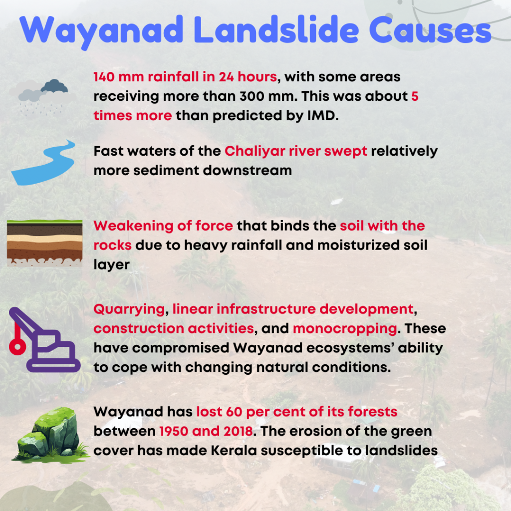
| Factors behind the Wayanad Landslide 1. Wayanad witnessed 140mm of rainfall, with some areas reporting more than 300 mm of rainfall. This rainfall was about five times more than India Meteorological Department’s (IMD) projections. 2. Overflow in the Chaliyar river swept more sediment downstream. This was due to the fact that heavy rains in 2020 had caused the Chaliyar to strip swaths of its upstream areas of plant cover. This left more rocks and humus vulnerable to being displaced. 3. The heavy rainfall has saturated with moisture. The water reaches the rocks by flowing between the soil and the rock layers. This weakens the force that binds the soil to the rocks and triggers the movement. 4. Quarrying, linear infrastructure development, and construction activities have compromised ecosystems’ ability to cope with changing natural conditions. 5. Monocropping, has resulted in the cut down of large, native trees, which serve to hold the topsoil to the bedrock. The replacement of these native trees with big plantation crops, such as tea and coffee having shallow roots, has increased the vulnerability. 6. According to a study by the International Journal of Environment and Public Health, Wayanad has lost 60 per cent of its forests between 1950 and 2018. The erosion of the green cover has made Kerala susceptible to landslides. 7. Climate Change has been leading to gradual warming of the Arabian Sea leading to the formation of a deep cloud system over parts of the Western Ghats. |
What are landslides? What is the status of India’s Vulnerability to Landslides?
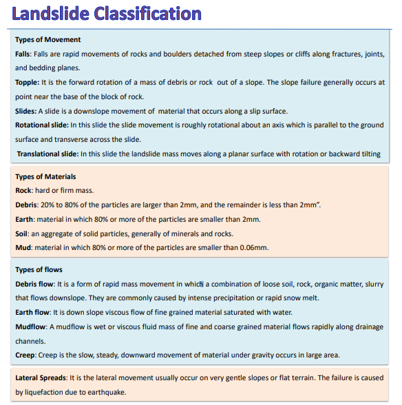
Landslide- It is a natural phenomenon which is usually observed in steep mountainous regions where large quantities of material, composed of rock, boulders, loose mud, soil and debris, are driven down the slope with force.
Types of Landslides
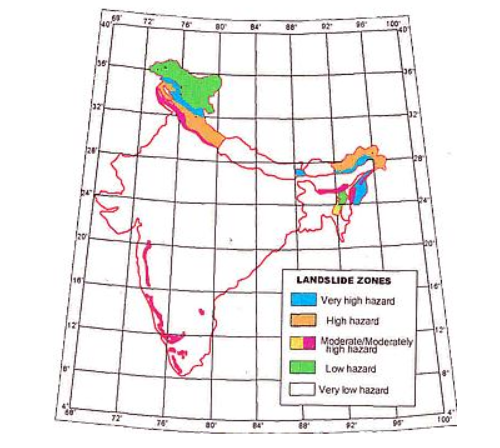
Vulnerability of India to Landslides
| ISRO’s Landslide Atlas of India | According to ISRO’s Landslide Atlas of India, India is among the top four countries with highest landslide risk. It has been estimated that loss of life per 100 km2 is greater than one. |
| India Landslide Susceptibility Map (ILSM) by IIT Madras | India accounts for about 8 per cent of global fatalities due to landslides. 13.17 per cent of the country is susceptible to landslides, and 4.75 per cent is ‘very highly susceptible’. Kerala is the most vulnerable state with over 14 per cent of its land mass in the ‘very high susceptibility’ category. |
Recent Incidents in India- Some other incidents in india include the following- Kerala (2018), Himachal Pradesh (2018), Uttarakhand (2018), Tamenglong-Manipur (2018), and Kalikhola, Manipur (June 2017).
| Read More- National Landslide Susceptibility Map |
What are the causes of landslides in India?
Natural causes
1. Heavy Rainfall- The occurrence of heavy or continuous rainfall may lead to heavy landslides in the areas of steep slopes. Water works as a lubricating agent and loosens up the material. For ex- The 2013 Uttarakhand Cloudburst brought immense landslides in the region.
2. Earthquakes- The sudden shaking of earth’s crust creates stress on materials resulting in their flow downwards. For ex- Tectonically active Himalayas enhance the probability of earthquakes, resulting in an increased vulnerability.
3. Nature of Rivers- The youthful and mighty rivers in increase the downcutting of earth on the mountain slopes. For ex- The increased flow in the Chaliyar river resulted in heavy sediment erosion, resulting in the Wayanad landslide catastrophe.
Anthropogenic causes
1. Heavy Infrastructure Development- The creation of roads, railways, dams, linear infrastructure development in the mountainous region, has resulted in increased landslides. For ex- The development of Konkan Railways in western ghats is considered a significant reason behind the frequent occurrences of the disaster in the region.
2. Mining activities- It involves removal of the surface of the earth for mineral exploration, which loosens the grip of material. For ex- Iron ore, bauxite, manganese, chromite, and limestone mining in the western ghats has increased the risks of this disaster.
3. Increased Deforestation- The cutting down of trees for agricultural and industrial activities, loosens the soil grip and makes the region more vulnerable to landslides. For ex- Plantation agriculture in Western ghats has resulted in loss of native trees and increased the disaster risk.
4. Unsustainable Tourism- The rising tourist influx in the Himalayan region and Western Ghats puts greater pressure on land, as more infrastructure and amenities are needed to accommodate them. This leads to more construction and greater landslide risks.
5. Climate change- Anthropogenic activities has accelerated the climate change events, leading to increased glacial melts and rainfall. For ex- Warming of Arabian sea has resulted in increased rainfall in the Western Ghats region, leading to enhanced landslides.
What are the Impacts of Landslides in India?
1. Loss of Lives- The most traumatizing impact of a landslide is the loss of precious human and animal lives. In the recent Wayanad case, already more than 250 deaths have been reported.
2. Economic Losses- These lead to enhanced economic losses as, significant amount is spent on reconstructing the lost infrastructure, rehabilitating the masses, and providing relief support to the impacted people.
3. Infrastructural Damage and restricted Movement- The mud, rocks, and debris moving down the slope result in infrastructural damage to houses, buildings, roads and create a barrier on critical transportation routes. This restricts the movement of goods and people.
4. Jeopardized Water Availability- The accumulated mass of debris results in the blockage of a river by creating a Landslide dam. It impairs the availability of water for nearby people.
5. Displacement and Migration- It forces communities to evacuate and migrate. This leads to social disruption and psychological stress among affected populations
What initiatives have been taken by the Government to mitigate the risks due to landslides?
| National Landslide Susceptibility Mapping (NLSM) | Geological Survey of India initiated the National Landslide Susceptibility Mapping (NLSM) program in 2014 to map the landslide areas on a Macro Scale (1:50,000). The goal is to map the 0.42 million sq. km landslide-prone areas across the country. |
| National Landslide Risk Management Strategy (2019) | It addresses all the components of landslide disaster risk reduction and management, which includes – a. Hazard mapping, monitoring, and early warning system, awareness programs, b. Capacity building, training, regulations, and policies, stabilization and mitigation |
| National Disaster Management Authority (NDMA) Guidelines on Landslide Hazard Management (2009) | It proposes measures that should be taken to avoid or mitigate the risk posed by landslide hazards. Some of the guidelines are as follows– a. Delineating areas susceptible to landslide hazards b. Encouraging implementation of successful remediation and mitigation technologies. c. Developing institutional capacity and training for geoscientists, engineers, and planners is necessary for the effective management. |
| National Institute of Disaster Management (NIDM) | It is a premier institute that provides Capacity Building support to various National and State level agencies in the field of Disaster Management & Disaster Risk Reduction. |
What are the challenges in implementation of measures proposed for landslide Mitigation?
1. Non implementation of Gadgil and Kasturirangan committee reports- The Gadgil committee report proposed to regulate developmental activities in the entire 1,60,000 sq km stretch of the Western Ghats. K Kasturirangan report recommended demarcation of 37 per cent of the Western Ghats as an ecologically sensitive area (ESA) and complete ban on mining and quarrying in these protected zones. These reports have not been implemented with resistance by all states and parties across the political spectrum in the biodiverse region.
2. Lack of landslide mitigation plan- Many States vulnerable to landslides including Kerala lack landslide mitigation plan. These maps and plans help to explain the route a landslide can take once it has been triggered.
3. Insufficient Monitoring Systems- Many regions lack effective monitoring and early warning systems, which are crucial for timely evacuation and disaster preparedness. The absence of real-time data lead to increased casualties and damage during landslide events.
4. Policy and Regulatory Gaps- Weak enforcement of land-use regulations and building codes often exacerbates vulnerability to landslides.
5. Low Community Awareness and Participation- Low levels of public awareness regarding landslide risks and preparedness measures impede community involvement in disaster management.
What Should be the Way Forward?
1. Drawing up of Route Maps- Route maps help in marking out areas which should be out of bounds for settlements or any activities. These maps also map out the routes that landslides are likely to take after they have been triggered. The route maps need to be drawn at the earliest to complement the susceptibility maps.
2. Proper Environment Impact Assessment- Proper implementation of Environmental impact assessment norms must be carried out before initiating mining or dam construction, in the ecologically fragile mountainous regions.
3. Demarcation of ecologically sensitive areas in Western Ghats- The panel headed by Sanjay Kumar must finalise the draft notification on ecologically sensitive areas for the western Ghats. This will help in reducing engineering projects in ecologically sensitive areas.
4. Landslide Micro-zoning procedure- There must be adoption of landslide micro zoning procedures for mountainous and other highly vulnerable regions. This will help the states in restoring denuded flora and soil cover.
5. Involvement of locally trained manpower- There should be involvement of locally available trained manpower to intensify the hazard reduction and public awareness programs.
| Read More- The Indian Express UPSC Syllabus- GS 3- Disaster and its Management |
Discover more from Free UPSC IAS Preparation Syllabus and Materials For Aspirants
Subscribe to get the latest posts sent to your email.