ForumIAS announcing GS Foundation Program for UPSC CSE 2025-26 from 27th May. Click Here for more information.
Source-This post on Aral Sea Shrinking is based on the article “How climate change is accelerating the ‘decades-long demise’ of the Aral Sea” published in “Hindustan Times” on 9th February 2024.
Why in the News?
Recently, NASA’s Earth Observatory shared an in-depth analysis of the factors contributing to the disappearance of the Aral Sea.
What are the factors responsible for disappearance of Aral Sea?
1. As per the space agency’s findings, in 1960, the Soviet Union initiated a significant water diversion project by redirecting the Syr Darya and Amu Darya rivers for irrigation purposes.
Note– The Aral Sea formed from water flowing from the Syr Darya and the Amu Darya rivers, which relied on glacial melt.
2. While the project caused the desert region surrounding the sea to flourish, it had a catastrophic effect on the Aral Sea. The waterbody began to dry up gradually and is now close to completely disappearing.
About Aral Sea

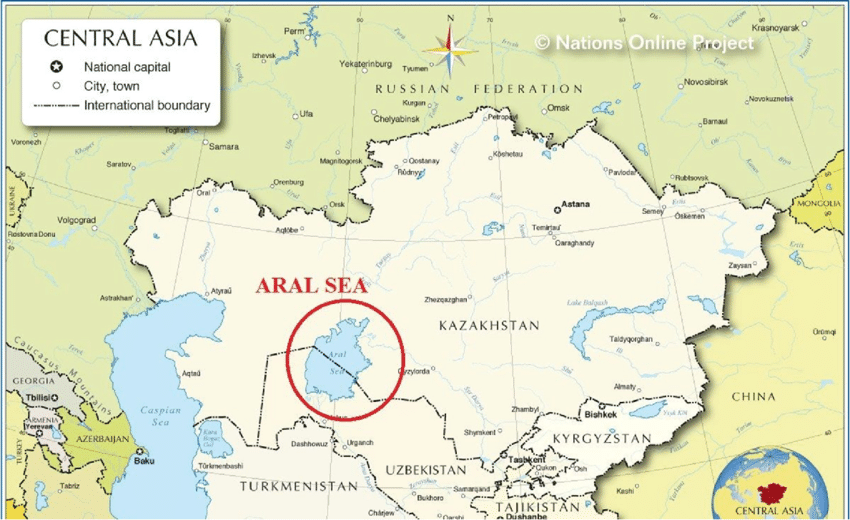
1. Borders– It marks the border between Kazakhstan to the north and Uzbekistan to the south.
2. Served fourth Largest Inland Water Body– It was once served as a vast saltwater lake in Central Asia and ranked as the world’s fourth largest inland water body.
3. Sea remains-The remaining fragments of the sea lie in the climatically harsh core of Central Asia, situated east of the Caspian Sea.
4. Emergence-The Aral Sea depression emerged towards the conclusion of the Neogene Period, spanning from approximately 23 to 2.6 million years ago.
5. Drainage– It encompasses drainage from Uzbekistan and parts of Kazakhstan, Tajikistan, Afghanistan, Turkmenistan, Iran, and Kyrgyzstan.
6. Climate– It is known for its harsh climate with hot summers, cold winters, and temperature changes throughout the day.
UPSC Syllabus- Geography and Places in News


