
ForumIAS LATEST
- SFG FRC 2027 | Program starts from 15th Dec. 2026 | Admissions open for Tranche-1 Entrance Test till 25th Oct. 2026 Click Here to know more →
- Prelims Test Series (PTS) for Prelims 2027 starts 11th Oct. 2026 Click Here to know more →
- [Pre-order] Ethics Redbook 3rd Edition: Delivery starts from 21st October onwards Click Here to Read More →
- 21 Sept. | GS Advance Program (GSAP) for UPSC 2027 Mains starts from 11th Oct. Click Here to Read More →
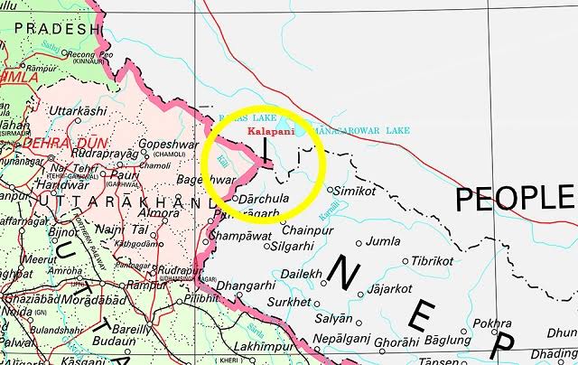
News:Nepal government has objected to the inclusion of ‘Kalapani’ under the Indian Territory as per the newly released political map of India after the bifurcation of Jammu and Kashmir.
Facts:
About Kalapani territory:
- Kalapani is a 35 square kilometre area.The Kali River in the Kalapani region demarcates the border between India and Nepal.
- Both India and Nepal claim Kalapani as an integral part of their territories with India as part of Uttarakhand’s Pithoragarh district and Nepal as part of the Darchula district.
- The Treaty of Sugauli signed by the Kingdom of Nepal and British India (after Anglo-Nepalese War) in 1816 located the Kali River as Nepal’s western boundary with India.
- However,the discrepancy in locating the source of the river led to boundary disputes between India and Nepal with each country producing maps supporting their own claims.
- The Prime Ministers of both the countries discussed the issue in 2000, with Indian PM assuring Nepal that India would not occupy even an inch of Nepal.
- Five years ago,the matter was referred to a new mechanism comprising foreign secretaries of both sides.