ForumIAS announcing GS Foundation Program for UPSC CSE 2025-26 from 19 April. Click Here for more information.
ForumIAS Answer Writing Focus Group (AWFG) for Mains 2024 commencing from 24th June 2024. The Entrance Test for the program will be held on 28th April 2024 at 9 AM. To know more about the program visit: https://forumias.com/blog/awfg2024
Contents
Source: The post is based on the article “ISRO releases the Landslide Atlas of India: Which states, regions are most vulnerable” published in Indian Express on 11th March 2023.
What is the News?
National Remote Sensing Centre (NRSC) under the Indian Space Research Organisation (ISRO) has released the Landslide Atlas of India, a detailed guide identifying Landslide Hotspots in the country.
What are Landslides?
How vulnerable is India to Landslides?

India is considered among the top five landslide-prone countries globally, where at least one death per 100 sq km is reported in a year due to a landslide event.
Rainfall variability pattern is the single biggest cause for landslides in the country, with the Himalayas and the Western Ghats remaining highly vulnerable.
Excluding snow covered areas, approximately 12.6% of the country’s geographical land area (0.42 million sq km) is prone to landslides.
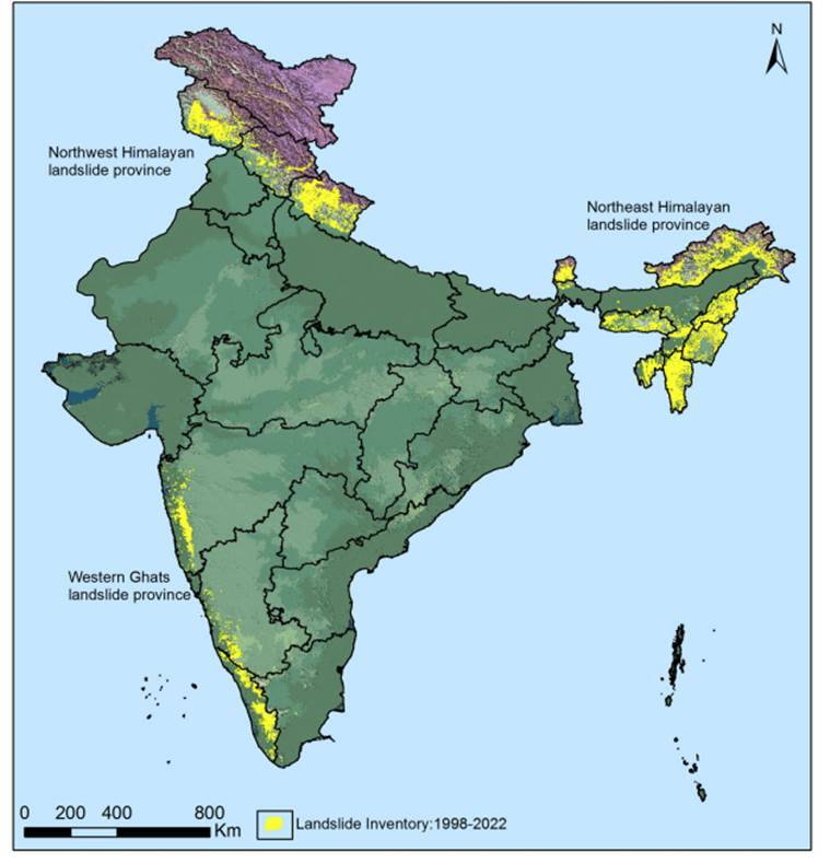
As many as 66.5% of the landslides are reported from the North-western Himalayas, about 18.8 per cent from the North-eastern Himalayas, and about 14.7% from the Western Ghats.
In the Western Ghats, despite fewer events, landslides were found to be making inhabitants significantly vulnerable to fatalities, especially in Kerala.
How was the Landslide Atlas of India prepared?
ISRO’s National Remote Sensing Centre (NRSC), Hyderabad has created a database of landslide-prone regions of India based on events during 1998 – 2022, primarily along the Himalayas and the Western Ghats.
In addition to aerial images, high resolution satellite images captured using cameras Indian Remote Sensing (IRS-1D) PAN + LISS-III, satellites ResourceSat-1 and 2, etc were used to study the landslides over the past 25 years.
What are the key highlights from Landslide Atlas of India released?
Uttarakhand, Kerala, Jammu and Kashmir, Mizoram, Tripura, Nagaland and Arunachal Pradesh reported the highest number of landslides during 1998 – 2022.
Mizoram topped the list, recording 12,385 landslide events in the past 25 years, of which 8,926 were recorded in 2017 alone. Mizoram is followed by Uttarakhand (11,219) and Kerala.
The number of districts with the maximum landslide exposure are in Arunachal Pradesh (16), Kerala (14), Uttarakhand and Jammu and Kashmir (13 each), Himachal Pradesh, Assam and Maharashtra (11 each), Mizoram (8) and Nagaland (7).


